This article was scraped from Rochester Subway. This is a blog about Rochester history and urbanism has not been published since 2017. The current owners are now publishing link spam which made me want to preserve this history.. The original article was published July 20, 2010 and can be found here.

A recent story in the City Newspaper, "Glamming Rochester's Gateways" touched on the idea that filling in part of the Inner Loop would help reconnect certain neighborhoods with downtown and improve Rochester's eastern gateways. Then came the raging comments from readers who blindly defended the inner loop and its many blessings .
One letter sent in from James R. Boehler went like this...
"This proposal is a solution without a problem and nothing more than a waste of tax dollars. Every major city has a center-city expressway to move traffic. How else do you get to your business and entertainment during parades, street closures, and detours for repairs? ... Closing the Inner Loop would just drive more business to the "burbs," including mine."
And comments on the City Newspaper site sounded like this...
"PLEASE do not fill in the inner loop. I live in the suburbs and I love the inner loop. I hate traffic. I hate traffic lights ... Where would the traffic go if the loop didn't exist?"
Whoa whoa whoa... STOP THE INSANITY! Let's all take a deep breath here. Have a seat in your lawn chairs while I attempt to straighten this out...

First, let's make sure we understand one thing: while the plan IS to fill part of the inner loop, the artery itself is not going away. There, now that we've got that cleared up, let's take a closer look at what is being proposed.
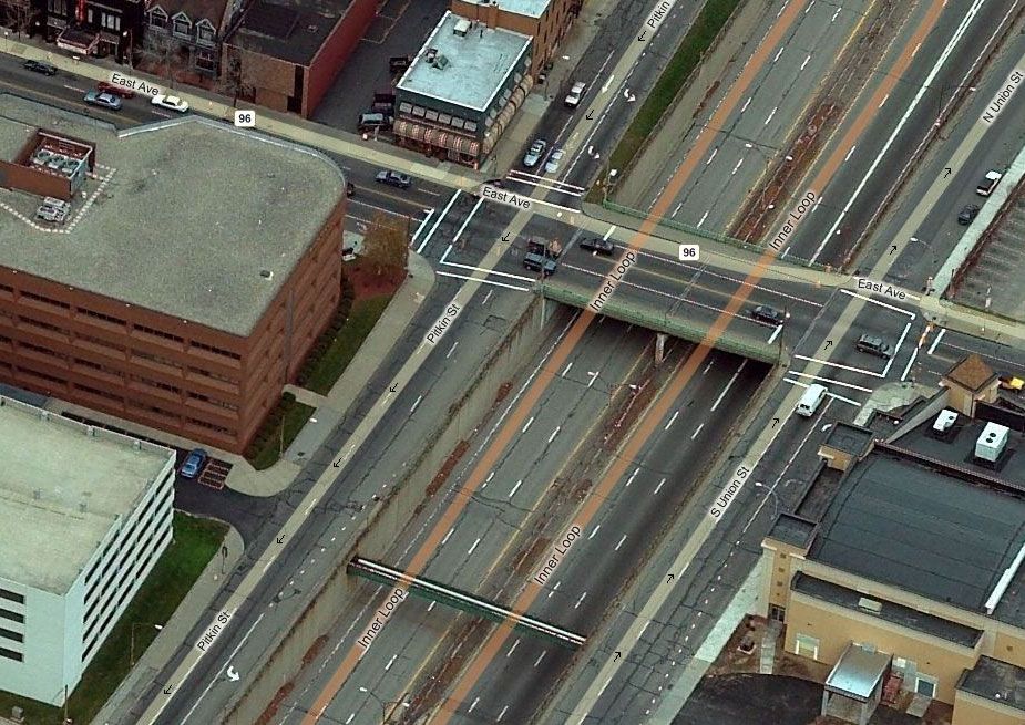
The City's plan is to bring the road surface up to grade-level from about Monroe Ave north to Charlotte Street. Suburbanites can relax. Your conduit to I-490 isn't going away. But it could be transformed into a pedestrian- and bike-friendly boulevard with reclaimed space along either side for new commercial and/or residential development (maybe even some landscaping).

Where there was once an empty canyon--imagine a vibrant streetscape with brand-new, taxpaying businesses and residents! Imagine the upper Monroe Ave and Park Ave neighborhoods once again connected to the downtown business district. Good lord, imagine anything other than the concrete moat that's there now.

In his letter Mr. Boehler also argues, "Every major city has a center-city expressway to move traffic." Maybe so, but when was the last time you were stuck in grid-lock traffic inside the Inner Loop? When was the last time you were caught in *any* kind of traffic?? I digress. I'd just like to point out that nearly every major city in the U.S. right now is considering at least one downgrade of a major intra-city expressway. NYC is wants to shut down part of the FDR Drive to traffic completely. Seattle wants to level it's infamous Alaskan Way . And closer to home, the NYSDOT is studying options to return Buffalo's Kensington Expressway to a surface boulevard. The Kensington is much busier and longer than our tiny Inner Loop. So don't think for a second that this is some kind of radical idea that is unique to Rochester, NY.
As it is today, Rochester's Inner Loop serves no purpose other than to whisk people away from downtown. It is a barrier between downtown and the promising neighborhoods to the east. It's bridges and concrete walls are literally crumbling and it is far more expensive to maintain than it is worth. THESE are the problems--and this plan is the start of a solution. I'd like to know what exactly what problem City planners were trying to fix when they decided to level hundreds of homes and businesses to build the inner noose?
![An aerial view of Rochester on April 25, 1963. On the right is the cleared right-of-way for the final segment of the Inner Loop. [PHOTO: Local History Division, Central Library of Rochester.]](https://www.rochestersubway.com/images/photos/rochester-inner-loop-construction-01.jpg?ref=senseofplace.dev)
Additional Resources: Inner Loop Project TIGER (Transportation Investment Generating Economic Recovery) grant application