This article was scraped from Rochester Subway. This is a blog about Rochester history and urbanism has not been published since 2017. The current owners are now publishing link spam which made me want to preserve this history.. The original article was published January 24, 2013 and can be found here.
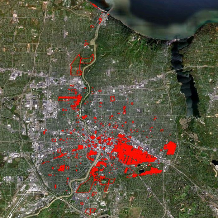
![A map of Rochester's Buildings of Historic Value [Thanks to: Jim Fraser and Joseph Becker]](https://www.rochestersubway.com/images/photos/rochester-designated-buildings-of-historic-value-map-01.jpg?ref=senseofplace.dev)
Scientists have known of the existence of DNA for over fifty years. But until recently
, no one had ever seen a photograph of that tricky little double-helix. For the preservation community in Rochester, the image above could be just as big of a breakthrough as photographing DNA for the first time. We had a fuzzy idea of their existence, but until today no one had ever seen a map of the city's Designated Buildings of Historic Value (DBHV). And I mean NO ONE. Not even the people who put the list together...

The DBHV list
contains some 4000 properties that are in, or said to be eligible for listing in, the National Register of Historic Places. But no one that I've spoken to (from Bret Garwood, Director of Business & Housing Development to Wayne Goodman, Landmark Society Executive Director) has any idea what this list really looks like, or how accurate it is.
In the wake of the failed effort last year to save the Cataract Brewery building, the DBHV list became the focus of critism. Preservationists came to view the list as an incomplete document without the necessary legal backing to protect the buildings on it. While Mayor Richards called for the size of the list to be dramatically reduced - from 4,000 properties possibly to as few as 100.
The one thing both sides seem to agree on is the list needs to be updated and prioritized. But who would take on the monumental task? The City doesn't have the human resources to put on the project. And non-profit groups like Landmark Society don't necessarily have the infrastructure or technical know-how to manage such a large amount of data. The job might be easier if we could SEE the data on a map. This is where average citizens (and Google) come in...

My good friend Jim Fraser, and Joseph Becker, a GPS specialist & IT consultant, have taken it upon themselves to painstakingly import the DBHV list into a Geographic Information System (GIS) so that every property on this list could be mapped and layered atop Google Earth.
Jim explains, "We wanted to create a tool that would allow the community to be more proactive about saving places. So this is the first deliverable of a project to create an interactive preservation planning tool to be available publicly on the internet."

In order to be able to prioritize these endangered places, we need to know two things: (1) what those places are, and (2) a definition for "endangered" that allows us to measure and prioritize. This mapping tool is a way to get both.
Jim says ultimately this mapping tool will have several layers. "The historic properties are the first layer. Other layers will show data from other stakeholders' perspectives. For example, a crime data layer or a building assessment layer could help to prioritize projects based on the risk of losing the building. Retail, demographic and developer data layers could help prioritize opportunities for development. Community leaders could add layers containing places of value within their communities. Each layer could assign a priority to each object on the map. The final calculation of priority that you'd see for each object would depend on which layers you are viewing. The result [will be] a tool that combines community perspectives and supports collaborative planning."

The map is already yielding exciting results, and raising new questions. For example, why is the Amtrak Station parking lot (outlined in red) on the list? Yet, right across the street, the beautiful old main post office building
is not? Or, why are there so many buildings worth saving in the City's southeast quadrant, but hardly any in the north/northwest? Perhaps this map will allow us to address some of these things now that we can SEE them before our eyes.
But Jim and Joseph will now need the support of City Hall and other stakeholders so that all community perspectives can be considered and included.
Until today, the DBHV list has remained a dark mystery primarily because of the way it has been compiled and added on to - over time, by various people, without much transparency. That all needs to change. But equally as challenging was the size and format of the list itself. In that regard, this map is nothing short of a breakthrough.