This article was scraped from Rochester Subway. This is a blog about Rochester history and urbanism has not been published since 2017. The current owners are now publishing link spam which made me want to preserve this history.. The original article was published August 25, 2015 and can be found here.
![Satellite before & after image of Rochester. [IMAGE: Google Earth via Nick Russo]](https://www.rochestersubway.com/images/photos/rochester-satellite-before-and-after-midtown-plaza.gif?ref=senseofplace.dev)
The following is a guest post submitted by Nick Russo .
Submit your story today .
I've always been a fan of Rochester Subway content which looks at our city from a different angle. I thought I might contribute something in turn, that looks at our city from an aerial angle.
I noticed this week that Google Earth had updated its imagery to include snapshots from as early as a month ago. It is now possible to follow a lot of tangible changes that have been going on in the city for a while. I put together a handful of before-and-afters
that I thought were interesting (to me anyway). Take a look at the album and see if you can spot the differences...
Filling the Inner Loop
![Satellite before & after image of Rochester. [IMAGE: Google Earth via Nick Russo]](https://www.rochestersubway.com/images/photos/rochester-satellite-before-and-after-inner-loop.gif?ref=senseofplace.dev)
Kodak Implosion
![Satellite before & after image of Rochester. [IMAGE: Google Earth via Nick Russo]](https://www.rochestersubway.com/images/photos/rochester-satellite-before-and-after-kodak-implosion.gif?ref=senseofplace.dev)
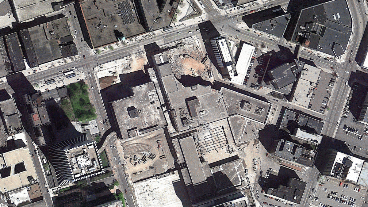
Carnegie Footprint
![Satellite before & after image of Rochester. [IMAGE: Google Earth via Nick Russo]](https://www.rochestersubway.com/images/photos/rochester-satellite-before-and-after-carnegie.gif?ref=senseofplace.dev)
Citygate and Interstate 390
![Satellite before & after image of Rochester. [IMAGE: Google Earth via Nick Russo]](https://www.rochestersubway.com/images/photos/rochester-satellite-before-and-after-citygate.gif?ref=senseofplace.dev)
Collegetown and
Golisano Children's Hospital
![Satellite before & after image of Rochester. [IMAGE: Google Earth via Nick Russo]](https://www.rochestersubway.com/images/photos/rochester-satellite-before-and-after-collegetown.gif?ref=senseofplace.dev)
Dredging at the Port of Rochester
![Satellite before & after image of Rochester. [IMAGE: Google Earth via Nick Russo]](https://www.rochestersubway.com/images/photos/rochester-satellite-before-and-after-port.gif?ref=senseofplace.dev)
RIT Gene Polisseni Center
![Satellite before & after image of Rochester. [IMAGE: Google Earth via Nick Russo]](https://www.rochestersubway.com/images/photos/rochester-satellite-before-and-after-rit.gif?ref=senseofplace.dev)
Mid Town Plaza - Street View
![Street View before & after image of Main Street, Rochester. [IMAGE: Google Street View]](https://www.rochestersubway.com/images/photos/rochester-streetview-before-and-after-main-street.gif?ref=senseofplace.dev)
Did you know you can also view historical images using Google Street View? Here's a timelapse of Main Street
at Midtown Plaza from the ground. Some pretty dramatic changes are happening around us every day if we just take a minute to notice. * * *