This article was scraped from Rochester Subway. This is a blog about Rochester history and urbanism has not been published since 2017. The current owners are now publishing link spam which made me want to preserve this history.. The original article was published August 27, 2012 and can be found here.
![Rochester Neighborhoods Map [BY: RochesterSubway.com]](https://www.rochestersubway.com/images/photos/rochester-neighborhoods-map.jpg?ref=senseofplace.dev)
Now you can admire your hometown of Rochester, NY and the diversity of its many communities without ever putting on a pair of pants.* Introducing two awesome new posters depicting the neighborhoods of Rochester...
![Neighborhoods of Rochester, New York [BY: Tanya and Jason of YoungLionRochester.com]](https://www.rochestersubway.com/images/photos/rochester-neighborhoods-map-younglion.jpg?ref=senseofplace.dev)
The first poster (shown left) is absolutely beautifully designed. It was put together by Tanya, Bill and Jason over at YoungLionRochester.com
. According to their site, it is meant to be "both a geographically-based map and graphic work of art." You can order a 4-color screen print on Mohawk VIA Vellum Cream paper from their site
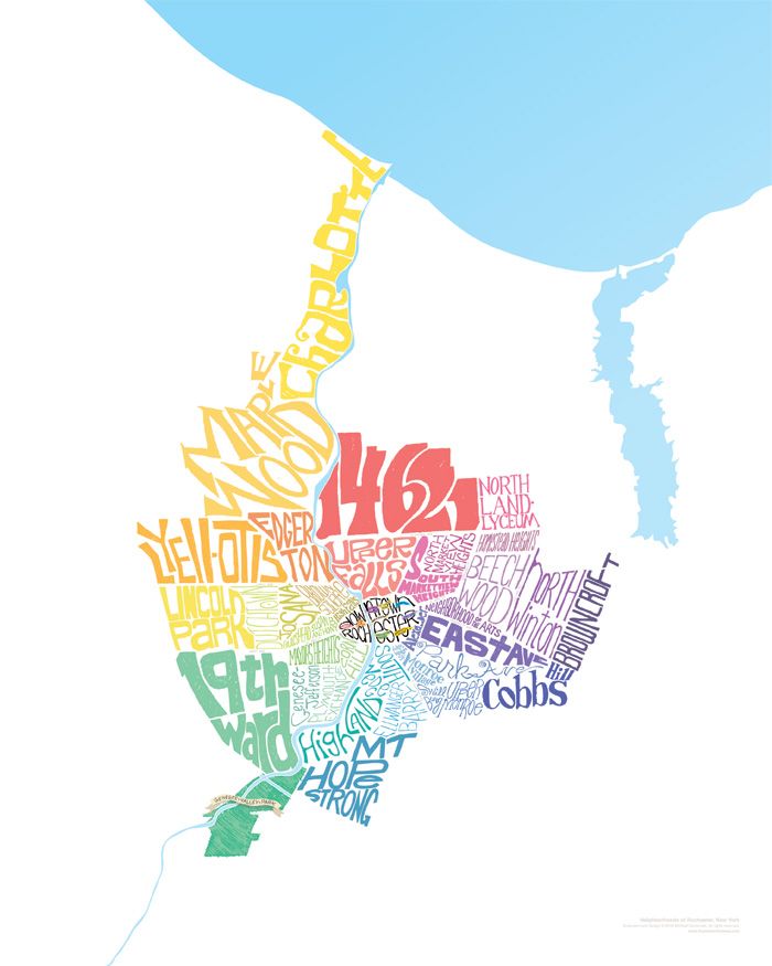
. While I love the aesthetic look/style of the YoungLion map, I thought there might be a more compelling way to represent the unique qualities of our neighborhoods. Something that conveys the idea of 'people' and 'culture' and 'excitement!' This map of San Francisco is getting there. But still, I thought, something's missing. So I took a shot and this is what I came up with .
![A close up of Downtown Rochester. [BY: RochesterSubway.com]](https://www.rochestersubway.com/images/photos/rochester-neighborhoods-map-downtown.jpg?ref=senseofplace.dev)
Thirty nine distinctively hand lettered neighborhoods, plus nine downtown districts all coexist in a vibrant and colorful patchwork--just like our town. And just as with the YoungLion map, the minimalist design approach focuses all our attention on the neighborhoods. In fact, the only geographic features shown are Lake Ontario, Irondequoit Bay, Genesee Valley Park and the river twisting its way through the center. [ You can Pre-Order this map before 9/10 for $16. Regular price: $20 ]
![A close up of Genesee Valley Park. [BY: RochesterSubway.com]](https://www.rochestersubway.com/images/photos/rochester-neighborhoods-map-genesee-valley-park.jpg?ref=senseofplace.dev)
The Erie Canal defines much of Rochester's south/west border, but only a snippet of the canal is shown as it cuts across Genesee Valley Park. And you'll notice that both maps exclude Durand Eastman Park. I wrestled with this decision. But ultimately because the park is surrounded entirely by the suburb of Irondequoit, and it doesn't border any Rochester neighborhoods, I decided it didn't belong on a "neighborhoods map". Also, the poster looks much nicer without it. Trust me.
Undoubtedly people will shout, "Hey jerk, you left out my neighborhood!" I do acknowledge, there are a few I left out intentionally. Primarily due to space restrictions and, as in the cases of ABC Streets and El Camino, they are widely considered part of a larger neighborhood. But, if you shout loud enough, you just might find your little pocket of Rochester on the map in future go-arounds.
I like to think of this as a 'living map' of our city. Rochester is a reflection of our neighborhoods - both the people who settled them, and those who live there now. They have changed over time--some more than others--and they will continue to reinvent themselves over future generations. And that is a beautiful thing.
Rochester Neighborhoods Shown:
Rochester Downtown Districts Shown:
*RochesterSubway.com strongly recommends experiencing your city by leaving your house/apartment once in a while and hitting the streets. For God's sake, put your pants on man.