This article was scraped from Rochester Subway. This is a blog about Rochester history and urbanism has not been published since 2017. The current owners are now publishing link spam which made me want to preserve this history.. The original article was published May 20, 2014 and can be found here.

The following is a guest post submitted by Matthew Denker .
Submit your story today .
Welcome back to our three part series on Charlotte. We've arrived at part three. This is it, the omega. If you recall, all the way back in part one , we said this part would be broken up into three sections:
1. Residential and Commercial Development;
2. Transportation; and
3. Governance.
So without further adieu, let's jump right in. Ok, one quick disclaimer, Charlotte as a whole is pretty big, too big for one little three part column. With that in mind, I'm cutting off Charlotte at Denise Road, similar to the other parts . Maybe someday I can write an addendum addressing the southern portion of the neighborhood. But enough of that - Onward!
Residential and Commercial Development
As we learned in part two of this series, there are currently about 4,100 people living in this part of Charlotte. That's certainly a bunch, but actually only half the number needed for the average grocery store in the US. You can see where this is going: 8,000 residents. At first blush, this would be nearly impossible. The current occupancy in Charlotte is barely more than two residents per unit. This is where we have room to grow without adding 2,000 units. If instead we target an average occupancy of three (roughly balanced between couples, families with one child, and families with two children), we are looking at building approximately 1,300 new units. Even this is quite a bit, and I don't know that we can make it, but let's see what we can do. Also, realize this is a year and a half worth of housing starts for all of Monroe County. Any construction like this would be staged.
As an overview, here's a map of all the proposed new construction...

In each of the following sections there will be close ups of the map with annotations. One other fantasyland note, all of this assumes the marina is not built exactly as proposed. It's probably too late for this exact vision, but maybe that will increase its appeal.
Let's start from the south and move north, since this takes us from the easiest parts to describe to the hardest.

The city just auctioned this land. I don't actually know the result of the auction, but I'm sure one of our regular readers will be able to chime in with what happened. In any event, the piece of land the city sold was 3.2 acres. There's actually some oversized lots that could be subdivided, but ignoring those, we should look at breaking this into 32 city sized lots (1/10th of an acre), and building 32 single family homes of a style compatible with the other homes. From the other homes on Denise Rd, a mix of craftsman and foursquare would look perfectly nice. These homes could be held exclusively for families and would add 32 units and 128 residents (don't worry, we'll keep a running total throughout the article).
Moving north, we get to the corner of Stutson and Lake
.

This is currently a parking lot owned by our good friends, the City of Rochester. It's a large piece of property, at about 2/3rds of an acre.

Yum! Well, what could go here? This is a great spot for a mixed-use building. In fact, if we just, turn around, we'll see...

Look, it's three stories of excellent. I actually recommend going four stories. The first three stories would be built to the street line, while the fourth story would be set back. I recommend the first three stories being built with the same sort of brick and picture window styling as this building while the fourth floor would be all glass. It's about 7,000 sq. ft. floor plates. This translates to a first floor space large enough for a chain pharmacy in addition to a few smaller spaces for local businesses. The upper floors could be broken into 16 large two-bedroom apartments. For the tally, we're at 48 units and 160 residents. Here's an example of what the building could look like:

Oh, one final thing, there are approximately 66 parking spaces on this lot right now. From Lake to River on Stutson is about 600 feet. If Stutson were reprogramed to have parking on both sides of the street, it would support 74 parking spaces. Doing this would result in a net gain of parking (since clearly no one is parked on Stutson right now). No dedicated parking would be built off-street for this building
Let us continue our northward trek.
![Instead of a parking lot here, this could be a truly magnificant park that leads toward the lighthouse that many Rochester residents don't even realize is here. [PHOTO: EichbergConstruction.com]](https://www.rochestersubway.com/images/photos/filling-in-charlotte-rochester-ny-30.gif?ref=senseofplace.dev)
The green areas are new park to build a sight line to the historic lighthouse
. This site is just a giant parking lot for Holy Cross Church. It could, instead be a truly magnificant park that leads toward the lighthouse that many Rochester residents don't even realize is here. This is another place where dedicated and underutilized asphalt could be translated to street parking available to everyone at all times.

The new building north of here and just south of the new trolley line (to be described in the transportation section, I promise) would be constructed on a pair of lots, again, owned by the City of Rochester. In total, this piece of land is 1.1 acres. It would easily support a building shaped like the Flats East Bank development in Cleveland. The building footprint would need to be reduced by about a third. It could also lose two stories in the process and be a six-story building with the curve tucked into the rail tracks. Parking would be provided on the first and second floors of the building to the back, against the tracks, with commercial space fronting Lake.

This would translate to approximately 150 apartments. With an average occupancy of 1.75, we've just raised our totals to 198 units and 422 residents. We're one-tenth of the way there.
For the northern-most portion of Charlotte, let's look at the west side of Lake; then the east.
![After restoring the block structure on the west side of Lake Ave, everything south of will be in-fill two family houses on city lots. [PHOTO: media.cleveland.com]](https://www.rochestersubway.com/images/photos/filling-in-charlotte-rochester-ny-33.gif?ref=senseofplace.dev)
After restoring the block structure on the west side of Lake Ave, everything south of Hincher
will be in-fill two family houses on city lots. By my calculations this yields approximately 36 new homes encompassing 72 units and approximately 180 new residents. We're at 270 and 602.
The newly created block surrounded by Ruggles, Hincher, Estes and Corrigan Streets would be made into a park honoring Charlotte's founding. The park would be programmed like Susan B. Anthony Park with a square of trees around the outside and a series of paths bisecting the open space in the middle. A statue of Robert Troup
cast in bronze would be the centerpiece of the park. To my knowledge, there is no memorial of Troup, and quite frankly, if the Fox Sisters warrant a memorial
in Rochester, why shouldn't he?
To the north of the park would be an L-shaped, 4-story building with offices on the first three floors facing the new park. A portion of the first floor facing the park would be reserved for a commercial space with outdoor seating. The three floors facing Estes Street
would be townhomes while the fourth floor would be apartments. Parking would be provided behind the office and commercial space on the first floor. There is space for 18-20 foot wide townhouses. There would be approximately 20 apartments on the 4th floor. All of these units would be larger, and would have an average occupancy of 4. This yields 38 more units, and 152 more residents. There would be up to 75k ft of commercial space available for professional offices. With the additional residents, Charlotte would be able to support additional doctors, dentists, lawyers, and real estate agents, and the space would be offered at a discount to local practices. While the commercial space might not be immediately profitable, it can be supported by the combined construction on the other city property.
Across Estes Street
from this building would be two additional structures containing approximately 235k sq. ft. of residential. This translates to roughly 250 apartments and 500 new residents. Both Estes and Ruggles Street
would be widened and landscaped to accommodate street parking on both sides.

Additionally, both public and residential parking would be built under the two buildings on Estes St. The waterline is deeper here, due to being up hill, and is significantly less expensive to build underground parking than on the other side of Lake Ave.
Speaking of the other side of Lake Avenue, we've arrived there and at the closing portions of this section.
The 6 buildings at the bottom are the easiest. There will be a streetcar stop right in the middle of them, and they (including the stop, I suppose) will look almost exactly like this:

In all, I imagine the construction of 1.6 million sq. ft. of apartments. At an average size of 1,000 sq. ft. per apartment, this translates to about 1,600 new units. With an average occupancy just over 2, it's 3,500 people, and can you believe it, we got there? We made it to 8,000 people (and then some). Not only did we do that, but also one of these buildings would have a full service grocery store in it. This number of people would also support a dozen restaurants. Slightly less than one space would be provided for each unit here and at least one space would be available to each unit in the park and ride lot described in the transportation section. No buildings here would be taller than 5 stories, and the frontage facing River Street will be all commercial.

You may be wondering what the plan is for north of Corrigan Street
. This is, I think, my favorite part of the whole thing. This is the attraction for everyone new to the neighborhood, and everyone who had been visiting all the parking lots before. A little slice of my favorite place on earth: Ocean City, NJ.

![Attractions would include go-karts, miniature golf, and an arcade and all the boardwalk eats one would know and love. [PHOTO: RivertonHistory.com]](https://www.rochestersubway.com/images/photos/filling-in-charlotte-rochester-ny-38.jpg?ref=senseofplace.dev)
There will be a boardwalk around the entire site. Attractions would include go-karts, miniature golf, and an arcade. There would also be custard (hopefully Abbotts), chocolate (hopefully Stever's), and all the other boardwalk eats one would know and love. There would be a hotel component with rooms exclusively on the second and third floors above the boardwalk spaces and looking over the lake. Parking for the hotel and limited parking for the attractions would be underneath, with additional parking in the park and ride lot (still coming, I swear).
Ok, enough buildings, I'm exhausted, let's look at upgrading the transportation network.
Transportation
The transportation improvements for Charlotte come in three primary forms. The first is a series of bike lanes to improve the safety and attractiveness of bicycling in the neighborhood. These are shown in orange on the master development map above. The second is a series of improvements to the #1 RTS bus route including a new limited stop service. The third, and final improvement is the co-creation of a heritage trolley line and the relocation of major parking assets to the newly demolished Russell Station Site.
BIKE LANES...
Any good plan for bike lanes in Charlotte starts and ends with Lake Avenue. Through the entire Charlotte neighborhood, Lake Ave runs in a reasonably wide right of way. Additionally, much of the sidewalk is currently buffered with a grass strip. Indeed, from sidewalk edge to sidewalk edge the street is about 90 feet wide. Let's give ourselves 80 feet to work with just to be safe. I imagine Lake Ave to be reprogrammed as such from Beach Ave to Ridge Rd (4.6 mi), but for the purposes of this article, we'll call it off at Denise Rd. (1.3 mi).

This is an aggressive version of the 4-3 road diet that has previously been proposed for Lake Ave. It also incorporates parking and median protected bike lanes. Further, while it's hard to show on Streetmix
, pedestrian refuges would be built at each intersection, reducing crossing distances significantly for pedestrians in the area. Here's a photo example:

BUS CHANGES...
One of the minor, but important transportation changes is a slight alteration to the #1 bus route. Currently, many buses start at Ontario Beach and travel south. With the addition of the Charlotte Park and Ride Lot (to be described in the final transportation section), all buses that currently start at the beach would start at the P&R. One other change would be the addition of limited stop service stopping only at the P&R, the beach, Ridge Rd, Lyell, and downtown. This service, running every 20 minutes at rush hour (7am-10am in the morning and 4pm-7pm in the evening) would cut travel times from Charlotte to downtown in half for commuters.
LAKE ONTARIO TROLLEY...
This is the big one. All of the development in Charlotte has to come at the expense of all of the parking in Charlotte. There is no feasible way to maintain the current level of parking (24 acres for the beach alone) while also building housing that caters to all levels of the market. Little known secret about the expensive units in Edgewater's proposal - 10-15% of the cost of each unit is for parking.
In any event, with the decommissioning and demolition of the Russell power plant
, a large piece of reasonably useless (brownfield) land is about to become available and here we shall build a 3,200 space Charlotte Park and Ride. Even better, this piece of land has a rail right of way from it nearly directly to the beach. How fortuitous. Let's use this to implement a heritage streetcar line to shuttle beach-goers and commuters from the P&R to downtown Charlotte. The parking could remain free, but the streetcar would be $.50 a ride. Drivers to the P&R could walk along Beach Ave (1.5 mi) or take the 1 bus from the P&R as well. The streetcar would be based loosely on the heritage line built in Kenosha, WI
.
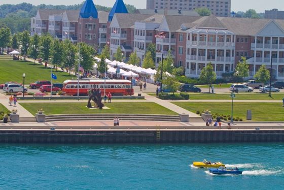
![A heritage streetcar line, like the one in Kenosha WI, could connect Ontario Beach with a parking lot at the former Russell power station. [PHOTO: CityPhile.com]](https://www.rochestersubway.com/images/photos/filling-in-charlotte-rochester-ny-41.jpg?ref=senseofplace.dev)
It would use PCC cars, and would be run with a fleet of three cars offering 10-minute service from 6am to midnight every day. The route is approximately 2 miles long, nearly all on dedicated right of way. The on street portion is on new streets built as part of the development. There would be 6 stops for the streetcar (as shown in the map). They would be at the Charlotte P&R, Greenleaf Rd, Spanish Gardens, Lake Ave, Riverside Dr & Portside Dr, and finally the Beach. Each PCC streetcar holds 104-134 passengers, meaning an hourly rate of 624-804 per hour. This will easily accommodate Charlotte beach-going, even on the busiest days of summer.

There is no reason to believe this project would cost significantly more than the Kenosha build. It has a few hundred more feet of track, but less than half as many stations. That means a heritage streetcar, a real attraction for Charlotte, could be had for less than one-third of the cost of the marina currently under construction.
Governance
The final piece of the final piece is about the governance of the new and improved Charlotte. We're 2,500 words in at this point, so I'll try to keep it brief. First, many of you know I strongly support Business Improvement Districts (BID)
. With that in mind, it should come as no surprise that I strongly support the assembly of a BID in Charlotte. The BID would be responsible for maintaining the enhanced streetscape and security in the neighborhood. It would also work with locals to open their own businesses. These second item, one for which I am infinitely indebted to Kyle Fecik, is a Parking Benefits District (PBD). All parking on Lake and River (and on side streets east of Lake) would be muni-metered. Additionally, while the park and ride would be free, the public parking in any new buildings would be pay, with the proceeds going to the PBD. Money from the PBD can be used to maintain other transportation improvements in Charlotte.
Fin
Well folks, it's been 3 weeks and nearly 5,000 words. I don't know if Charlotte will change or not. I don't know if the marina will succeed or not. This column series has been a real experience to pull together. Charlotte has a long and storied history (interestingly longer than Rochester itself). It is with that historic wind at their sails that I hope the residents of Charlotte are able to articulate a coherent vision of future Charlotte and then see it realized. Charlotte, and the city of Rochester as a whole, would be better off for it. Thank you for reading this all the way through.
* * *
About Matthew Denker:
Matthew Denker is a Project Director by day and a fantasy real estate tycoon by night. He has a deep interest in Rochester, NY, as well as the subjects of new urbanism, walkability, mass transit, and land use. Going forward he hopes to combine all of those things to make Rochester a city competitive not only with other small, successful cities, such as Portland and Minneapolis, but even better by leveraging its easy access to the world-class cities of Toronto and New York.