This article was scraped from Rochester Subway. This is a blog about Rochester history and urbanism has not been published since 2017. The current owners are now publishing link spam which made me want to preserve this history.. The original article was published April 30, 2014 and can be found here.

The following is a guest post submitted by Matthew Denker .
Submit your story today .
Welcome, readers, to the first of a three part series on Charlotte. This first part will serve as an introduction to the series and a brief history of Charlotte. The second part will be a survey, in the engineering sense, of the current state of Charlotte. It will include the demographics of the neighborhood and the built environment, as they exist today. Finally, the third part will layout a vision for Charlotte that works to harness all of the potential of the neighborhood. This final part will be broken into recommendations for residential and commercial development, transportation, and governance.
The plans described here will be ambitious, but we shouldn't let ourselves shy away from ambition - as you may know, Charlotte has recently been in the news
over some redevelopment plans. While Filling-In believes both plans have virtues, they both have numerous weaknesses as well. Because we are unassociated with any of the plans currently in play, and will believe they are built when we see it, the plans presented here will assume they did not happen, and instead will show a different vision of Charlotte's future.
But now, we present a brief history of Charlotte.

In 1801, Robert Troup named the nascent town Charlottesburgh, after his daughter. William Hincher had erected the first building in town some 10 years before. In 1805, Congress made the town an official port of entry to the US as the port of Genesee. Samuel Latta, namesake of the road, was appointed the first collector (tariffs, of course). Charlotte, do to greatly increased trade with Canada was well on its way to becoming a city until construction of the Erie Canal shifted the bulk of shipping through Rochester. (Peck, William (1908). History of Rochester and Monroe county, New York. The Pioneer publishing company. p. 44.)
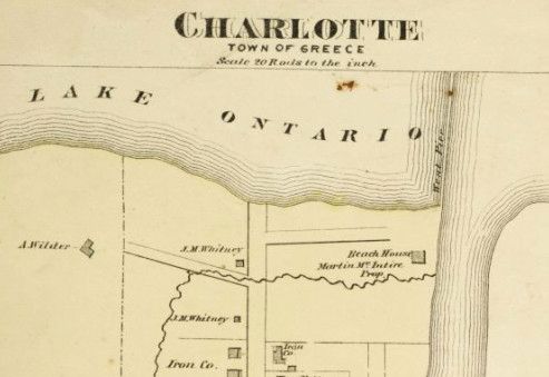
This map shows how Charlotte looked shortly after the civil war.
It would soon become a resort destination. The Charlotte Beach Improvement Company formed in 1884 for the purpose of building a new, better resort, and by 1889, electric trolleys connected Charlotte to downtown Rochester.
Vehicular ferry service was started between Charlotte and Canada in 1907, and ran until 1949 - never to be resumed [sic].
In 1916, Charlotte was annexed by the City of Rochester. At the time, there were 2,000 people living in the town. This wasn't the first time the idea of annexation had been raised, having come up in 1875 and 1893. Surprisingly, it was probably temperance that did Charlotte in. By 1900 there were 35 saloons for only 28 primary street corners. By 1915, the people of Charlotte were considered so disorderly (and heavens, drunk on Sundays), that the only way it seemed possible to clean the town up would be a city police precinct. 1
By the 1936 Plat Maps, Charlotte was already a sea of parking (in the photos at the end, you'll see this happened in 1921). I suppose that makes these lots historic, but maybe not worth preserving.

From then until the fast ferry in 2004, it doesn't appear much happened in Charlotte other than a mass renaming of streets.
Here now, to close out the article, are some great photos of Charlotte throughout history.
![There is the lighthouse in 1863. [PHOTO: Rochester Public Library]](https://www.rochestersubway.com/images/photos/filling-in-charlotte-rochester-ny-03.jpg?ref=senseofplace.dev)
There is the lighthouse in 1863.
![This is the Spencer House Hotel in 1873. [PHOTO: Rochester Public Library]](https://www.rochestersubway.com/images/photos/filling-in-charlotte-rochester-ny-04.jpg?ref=senseofplace.dev)
This is the Spencer House Hotel in 1873.
![This is a photo of the boardwalk from the 1880s. [PHOTO: Rochester Public Library]](https://www.rochestersubway.com/images/photos/filling-in-charlotte-rochester-ny-05.jpg?ref=senseofplace.dev)
This is a photo of the boardwalk from the 1880s.
![The beach and park in 1895. [PHOTO: Rochester Public Library]](https://www.rochestersubway.com/images/photos/filling-in-charlotte-rochester-ny-06.jpg?ref=senseofplace.dev)
The beach and park in 1895.
![This is the transit shed, shown on the plat maps. [PHOTO: Rochester Public Library]](https://www.rochestersubway.com/images/photos/filling-in-charlotte-rochester-ny-07.jpg?ref=senseofplace.dev)
This is the transit shed, shown on the plat maps.
![And here's an alternate view. [PHOTO: Albert R. Stone]](https://www.rochestersubway.com/images/photos/filling-in-charlotte-rochester-ny-08.jpg?ref=senseofplace.dev)
And here's an alternate view.
![A particularly icy year at the lighthouse. [PHOTO: Albert R. Stone]](https://www.rochestersubway.com/images/photos/filling-in-charlotte-rochester-ny-09.jpg?ref=senseofplace.dev)
A particularly icy year at the lighthouse.
![Here is the police station they were so hot to trot about in the town now formerly known as Charlotte. [PHOTO: Albert R. Stone]](https://www.rochestersubway.com/images/photos/filling-in-charlotte-rochester-ny-10.jpg?ref=senseofplace.dev)
Here is the police station they were so hot to trot about in the town now formerly known as Charlotte.
![These are some fantastic summer homes along Beach Ave. also around the time of annexation. [PHOTO: Albert R. Stone]](https://www.rochestersubway.com/images/photos/filling-in-charlotte-rochester-ny-11.jpg?ref=senseofplace.dev)
These are some fantastic summer homes along Beach Ave. also around the time of annexation.
![The oldest house in Charlotte, located at 4435 Lake Avenue, was built in 1806 by Samuel Latta. [PHOTO: Albert R. Stone]](https://www.rochestersubway.com/images/photos/filling-in-charlotte-rochester-ny-12.jpg?ref=senseofplace.dev)
The oldest house in Charlotte, located at 4435 Lake Avenue, was built in 1806 by Samuel Latta. British soldiers occupied this house during the War of 1812. In 1919 Mrs. Sarah Meech lived in the house with her brother and adopted son. Mrs. Meech was born in Parma, ca. 1839, and was the daughter of Elias Curtis.
![These are all buildings on the beach torn down for the bathhouse shown in the 1936 plat maps. [PHOTO: Albert R. Stone]](https://www.rochestersubway.com/images/photos/filling-in-charlotte-rochester-ny-13.jpg?ref=senseofplace.dev)
These are all buildings on the beach torn down for the bathhouse shown in the 1936 plat maps.
![A view of the corner of Lake and Beach Avenues where stores will be removed for a parking lot. [PHOTO: Albert R. Stone]](https://www.rochestersubway.com/images/photos/filling-in-charlotte-rochester-ny-14.jpg?ref=senseofplace.dev)
A view of the corner of Lake and Beach Avenues where stores will be removed for a parking lot. Caption with photo reads: "Old landmarks to be removed for the betterment of Ontario Beach Park". Author's note: 1921 - barf.
![A view of Beach Avenue west of Lake Avenue. Buildings to be torn down for an automobile parking space are pictured as well as Manitou Trolley tracks in the foreground and the Charlotte blast furnace and chimney in the background. [PHOTO: Albert R. Stone]](https://www.rochestersubway.com/images/photos/filling-in-charlotte-rochester-ny-15.jpg?ref=senseofplace.dev)
A view of Beach Avenue west of Lake Avenue. Buildings to be torn down for an automobile parking space are pictured as well as Manitou Trolley tracks in the foreground and the Charlotte blast furnace and chimney in the background. Published caption reads: "Old landmarks removed for the betterment of Ontario Beach Park". Author - still 1921 - still barfing.
![You won't believe what happened to this building in 1921 either. [PHOTO: Albert R. Stone]](https://www.rochestersubway.com/images/photos/filling-in-charlotte-rochester-ny-16.jpg?ref=senseofplace.dev)
You won't believe what happened to this building in 1921 either.
![Here's the playground at Ontario State Beach Park in 1941. Note the totally awesome seesaws that totally unawesomely do not exist anymore. [PHOTO: Rochester Municipal Archives]](https://www.rochestersubway.com/images/photos/filling-in-charlotte-rochester-ny-17.jpg?ref=senseofplace.dev)
Here's the playground at Ontario State Beach Park in 1941. Note the totally awesome seesaws that totally unawesomely do not exist anymore.
![These buildings still exist! [PHOTO: City Hall Photo Lab]](https://www.rochestersubway.com/images/photos/filling-in-charlotte-rochester-ny-18.jpg?ref=senseofplace.dev)
still exist!
To be continued...
1. Barnes, Joseph W. (January 1975). "The Annexation of Charlotte". Rochester History (Rochester Public Library). XXXVII (1). * * *
About Matthew Denker:
Matthew Denker is a Project Director by day and a fantasy real estate tycoon by night. He has a deep interest in Rochester, NY, as well as the subjects of new urbanism, walkability, mass transit, and land use. Going forward he hopes to combine all of those things to make Rochester a city competitive not only with other small, successful cities, such as Portland and Minneapolis, but even better by leveraging its easy access to the world-class cities of Toronto and New York.