This article was scraped from Rochester Subway. This is a blog about Rochester history and urbanism has not been published since 2017. The current owners are now publishing link spam which made me want to preserve this history.. The original article was published October 20, 2013 and can be found here.
![The fifth and final part of Ryan Green's Bike Rochester Series... the El Camino and Route 390 Trails! [PHOTO: Ryan Green]](https://www.rochestersubway.com/images/photos/rg-bike-rochester-el-camino-and-route-390-trails-014.jpg?ref=senseofplace.dev)
The following is a guest post submitted by Ryan Green .
Submit your story today .
This is the final part of my series on Rochester's plethora of trails! However, there are still many which I haven't covered. For a more complete list and description of trails in the region, check out Rochester Trails
. If you haven't, check out the past segments we have covered: Downtown to Fairport
, and the Genesee Valley Greenway and Lehigh Valley Trail loop
.
This final part serves to tie up some loose ends, and to showcase additional trail options and connections in the region. Here, we will go on an alternative route North to the lake, this time on the east side of the river gorge, and check out the parkway and Route 390 trails, which provide us with additional connections. [View this route in Google Earth using this .KMZ file ]
![his route is 28.8 miles: Downtown to the El Camino Trail, Seneca Park, Lake Ontario State Parkway (L.O.S.P.) and 390 trails, and finally back on the Canal Trail and Riverway Trail to the city. [IMAGE: Google Maps]](https://www.rochestersubway.com/images/photos/rg-bike-rochester-el-camino-and-route-390-trails-001.jpg?ref=senseofplace.dev)
The route almost resembles a mirror image of the state of New Jersey. It is 28.8 miles: Downtown to the El Camino Trail, Seneca Park, Lake Ontario State Parkway (L.O.S.P.) and 390 trails, and finally back on the Canal Trail and Riverway Trail to the city. Relatively calm road connections will link us to these trails.
![Staring off downtown, as per usual, we pass High Falls. [PHOTO: Ryan Green]](https://www.rochestersubway.com/images/photos/rg-bike-rochester-el-camino-and-route-390-trails-002.jpg?ref=senseofplace.dev)
Staring off downtown, as per usual, we pass High Falls.
![Then head north on St. Paul Street. [PHOTO: Ryan Green]](https://www.rochestersubway.com/images/photos/rg-bike-rochester-el-camino-and-route-390-trails-003.jpg?ref=senseofplace.dev)
Then head north on St. Paul Street.
![Until we turn right on Scrantom Street. [PHOTO: Ryan Green]](https://www.rochestersubway.com/images/photos/rg-bike-rochester-el-camino-and-route-390-trails-004.jpg?ref=senseofplace.dev)
Until we turn right on Scrantom Street.
![After a couple blocks we see the sign for El Camino Trail. [PHOTO: Ryan Green]](https://www.rochestersubway.com/images/photos/rg-bike-rochester-el-camino-and-route-390-trails-005.jpg?ref=senseofplace.dev)
After a couple blocks we see the sign
for El Camino Trail
.
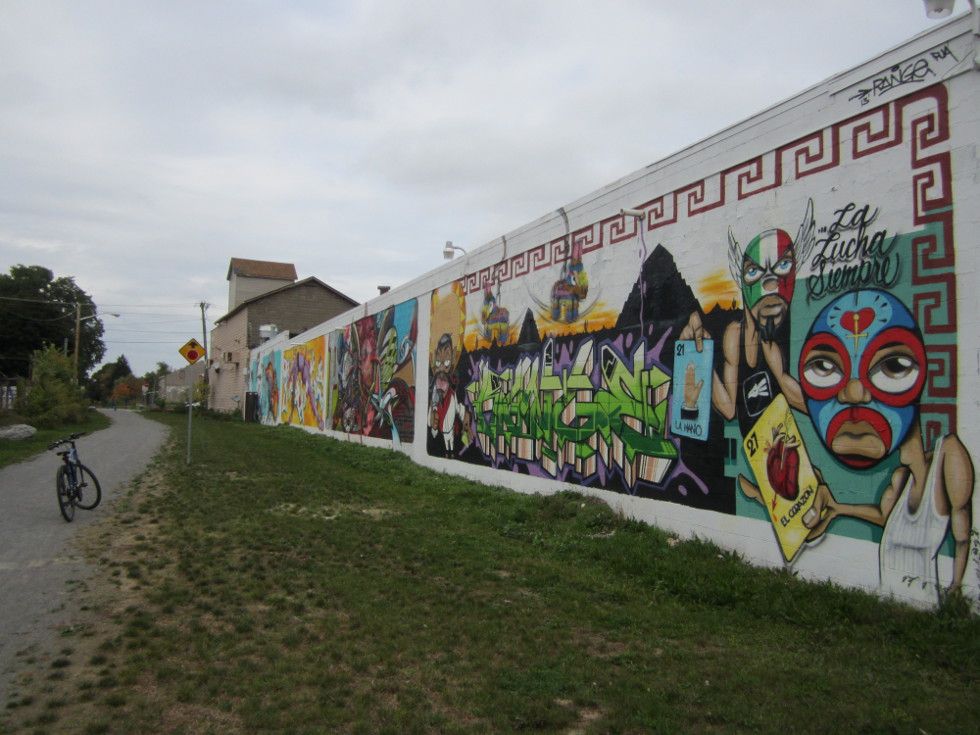
Some images from El Camino and a few Wall\Therapy murals, a wonderful and unique addition to Rochester's trails:
![Some images from El Camino and a few Wall\Therapy murals, a wonderful and unique addition to Rochester's trails. [PHOTO: Ryan Green]](https://www.rochestersubway.com/images/photos/rg-bike-rochester-el-camino-and-route-390-trails-006.jpg?ref=senseofplace.dev)
![Some images from El Camino and a few Wall\Therapy murals, a wonderful and unique addition to Rochester's trails. [PHOTO: Ryan Green]](https://www.rochestersubway.com/images/photos/rg-bike-rochester-el-camino-and-route-390-trails-007.jpg?ref=senseofplace.dev)
![Some images from El Camino and a few Wall\Therapy murals, a wonderful and unique addition to Rochester's trails. [PHOTO: Ryan Green]](https://www.rochestersubway.com/images/photos/rg-bike-rochester-el-camino-and-route-390-trails-008.jpg?ref=senseofplace.dev)
![Some images from El Camino and a few Wall\Therapy murals, a wonderful and unique addition to Rochester's trails. [PHOTO: Ryan Green]](https://www.rochestersubway.com/images/photos/rg-bike-rochester-el-camino-and-route-390-trails-009.jpg?ref=senseofplace.dev)
![Some images from El Camino and a few Wall\Therapy murals, a wonderful and unique addition to Rochester's trails. [PHOTO: Ryan Green]](https://www.rochestersubway.com/images/photos/rg-bike-rochester-el-camino-and-route-390-trails-010.jpg?ref=senseofplace.dev)
![Some images from El Camino and a few Wall\Therapy murals, a wonderful and unique addition to Rochester's trails. [PHOTO: Ryan Green]](https://www.rochestersubway.com/images/photos/rg-bike-rochester-el-camino-and-route-390-trails-011.jpg?ref=senseofplace.dev)
![Some images from El Camino and a few Wall\Therapy murals, a wonderful and unique addition to Rochester's trails. [PHOTO: Ryan Green]](https://www.rochestersubway.com/images/photos/rg-bike-rochester-el-camino-and-route-390-trails-012.jpg?ref=senseofplace.dev)
![Some images from El Camino and a few Wall\Therapy murals, a wonderful and unique addition to Rochester's trails. [PHOTO: Ryan Green]](https://www.rochestersubway.com/images/photos/rg-bike-rochester-el-camino-and-route-390-trails-013.jpg?ref=senseofplace.dev)
![Some images from El Camino and a few Wall\Therapy murals, a wonderful and unique addition to Rochester's trails. [PHOTO: Ryan Green]](https://www.rochestersubway.com/images/photos/rg-bike-rochester-el-camino-and-route-390-trails-015.jpg?ref=senseofplace.dev)
![At the end of the trail, there is a link to St. Paul Blvd. [PHOTO: Ryan Green]](https://www.rochestersubway.com/images/photos/rg-bike-rochester-el-camino-and-route-390-trails-016.jpg?ref=senseofplace.dev)
At the end of the trail, there is a link to St. Paul Blvd, which also has bike lanes at this point (but only within the city).
![Saint Paul also has bike lanes but only within the city. [PHOTO: Ryan Green]](https://www.rochestersubway.com/images/photos/rg-bike-rochester-el-camino-and-route-390-trails-018.jpg?ref=senseofplace.dev)
![We take a left, and head into Seneca Park/Seneca Park Zoo. [PHOTO: Ryan Green]](https://www.rochestersubway.com/images/photos/rg-bike-rochester-el-camino-and-route-390-trails-017.jpg?ref=senseofplace.dev)
We take a left, and head into Seneca Park/Seneca Park Zoo.
![Seneca Park/Seneca Park Zoo. [PHOTO: Ryan Green]](https://www.rochestersubway.com/images/photos/rg-bike-rochester-el-camino-and-route-390-trails-019.jpg?ref=senseofplace.dev)
![We pass by the Pure Waters Pedestrian Bridge. [PHOTO: Ryan Green]](https://www.rochestersubway.com/images/photos/rg-bike-rochester-el-camino-and-route-390-trails-020.jpg?ref=senseofplace.dev)
We pass by the Pure Waters Pedestrian Bridge, which links to the Genesee Riverway Trail
on the west of the river gorge.
One of the main reasons I chose this route, was to see what the paths were like on this side of the river. Google maps (but not the city's official bicycle plan) shows the east side Riverway Trail coinciding with the trails in the park. However, the trails, which are typically near mountain bike conditions, are closed to bikes according to signs I've read. The park is operated by Monroe County, and I haven't received an official explanation of bicycle permitted trails in the park.
Here are some images along the path, which provides incredible glimpses of the river gorge through the trees:
![Along the Seneca Park path. [PHOTO: Ryan Green]](https://www.rochestersubway.com/images/photos/rg-bike-rochester-el-camino-and-route-390-trails-022.jpg?ref=senseofplace.dev)
![Along the Seneca Park path. [PHOTO: Ryan Green]](https://www.rochestersubway.com/images/photos/rg-bike-rochester-el-camino-and-route-390-trails-023.jpg?ref=senseofplace.dev)
![Along the Seneca Park path. [PHOTO: Ryan Green]](https://www.rochestersubway.com/images/photos/rg-bike-rochester-el-camino-and-route-390-trails-024.jpg?ref=senseofplace.dev)
![Along the Seneca Park path. [PHOTO: Ryan Green]](https://www.rochestersubway.com/images/photos/rg-bike-rochester-el-camino-and-route-390-trails-025.jpg?ref=senseofplace.dev)
![Along the Seneca Park path. [PHOTO: Ryan Green]](https://www.rochestersubway.com/images/photos/rg-bike-rochester-el-camino-and-route-390-trails-026.jpg?ref=senseofplace.dev)
![Trout Lake, Seneca Park. [PHOTO: Ryan Green]](https://www.rochestersubway.com/images/photos/rg-bike-rochester-el-camino-and-route-390-trails-027.jpg?ref=senseofplace.dev)
Trout Lake.
![Trout Lake, Seneca Park. [PHOTO: Ryan Green]](https://www.rochestersubway.com/images/photos/rg-bike-rochester-el-camino-and-route-390-trails-028.jpg?ref=senseofplace.dev)
![Along the Seneca Park path. [PHOTO: Ryan Green]](https://www.rochestersubway.com/images/photos/rg-bike-rochester-el-camino-and-route-390-trails-029.jpg?ref=senseofplace.dev)
![Along the Seneca Park path. [PHOTO: Ryan Green]](https://www.rochestersubway.com/images/photos/rg-bike-rochester-el-camino-and-route-390-trails-030.jpg?ref=senseofplace.dev)
![Along the Seneca Park path. [PHOTO: Ryan Green]](https://www.rochestersubway.com/images/photos/rg-bike-rochester-el-camino-and-route-390-trails-031.jpg?ref=senseofplace.dev)
![There are a handful of diverting trails here. [PHOTO: Ryan Green]](https://www.rochestersubway.com/images/photos/rg-bike-rochester-el-camino-and-route-390-trails-032.jpg?ref=senseofplace.dev)
There are a handful of diverting trails here.
Eventually, we leave the trails at Seneca Park Ave, which is a little tricky to find. The trails do continue north, though I didn't explore them on foot.
![At the exit to the park onto the street, we cross an old railroad right of way, which looks friendly to bicycles. Perhaps, this is a the proper, albeit much less scenic, bicycle route to take through the park. [PHOTO: Ryan Green]](https://www.rochestersubway.com/images/photos/rg-bike-rochester-el-camino-and-route-390-trails-033.jpg?ref=senseofplace.dev)
At the exit to the park onto the street, we cross an old railroad right of way, which looks friendly to bicycles. Perhaps, this is a the proper, albeit much less scenic, bicycle route to take through the park. It looks like you can catch it by the entrance to the zoo
at Saint Paul Blvd.
From the City's 2010 bike plan , it looks like this is part of the proposed Irondequoit Trail. More info about the trail plan here
. According to the city official I spoke to, this trail has little support at present time (neighbors have opposed the plan for some reason). Riding on St. Paul Blvd is another viable option.

We exit Seneca Park onto Seneca Park Avenue. This section of Irondequoit is known as "The Flats" because... well, it's flat.
According to this D&C article
, "The Flats formed as a basin of the Genesee River and lies in a bowl about 65 feet below St. Paul Boulevard. Current zoning restrictions and nearby wetlands make it unlikely that more development will occur here."
Be sure to watch for deer. And in the Fall look out for bow hunters!
Turning left now onto St. Joseph St, then Van Voorhis Ave, and finally Thomas Ave. All of which are very calm roads.
![The Flats, in Irondequoit. [PHOTO: Ryan Green]](https://www.rochestersubway.com/images/photos/rg-bike-rochester-el-camino-and-route-390-trails-035.jpg?ref=senseofplace.dev)
![The Flats, in Irondequoit. [PHOTO: Ryan Green]](https://www.rochestersubway.com/images/photos/rg-bike-rochester-el-camino-and-route-390-trails-036.jpg?ref=senseofplace.dev)
![We then reach Pattonwood Drive. We can take a right onto the Irondequoit Lakeside Multi-Use Trail (East), or a left into Charlotte. [PHOTO: Ryan Green]](https://www.rochestersubway.com/images/photos/rg-bike-rochester-el-camino-and-route-390-trails-037.jpg?ref=senseofplace.dev)
We then reach Pattonwood Drive. We can take a right onto the Irondequoit Lakeside Multi-Use Trail (East), or a left into Charlotte, Rochester's harbor, which provides connections to the Genesee Riverway Trail (South) and the Lake Ontario State Parkway (L.O.S.P.) Trail (West).
![We'll head into Charlotte, take a right on Lake Ave, then a Left on Stutson Street. [PHOTO: Ryan Green]](https://www.rochestersubway.com/images/photos/rg-bike-rochester-el-camino-and-route-390-trails-038.jpg?ref=senseofplace.dev)
We'll head into Charlotte, take a right on Lake Ave, then a Left on Stutson Street.
![Overlooking the Genesee Riverway Trail and the Port of Rochester from the O'rorke Bridge. [PHOTO: Ryan Green]](https://www.rochestersubway.com/images/photos/rg-bike-rochester-el-camino-and-route-390-trails-039.jpg?ref=senseofplace.dev)
![Welcome to Charlotte. [PHOTO: Ryan Green]](https://www.rochestersubway.com/images/photos/rg-bike-rochester-el-camino-and-route-390-trails-040.jpg?ref=senseofplace.dev)
![Welcome to Charlotte. [PHOTO: Ryan Green]](https://www.rochestersubway.com/images/photos/rg-bike-rochester-el-camino-and-route-390-trails-041.jpg?ref=senseofplace.dev)
![After a left onto Latta Road, we see the entrance to the Lake Ontario State Parkway trail. This trail is right alongside the parkway and mainly serves as an easy connection to points West. [PHOTO: Ryan Green]](https://www.rochestersubway.com/images/photos/rg-bike-rochester-el-camino-and-route-390-trails-042.jpg?ref=senseofplace.dev)
After a left onto Latta Road, we see the entrance to the L.O.S.P. trail. You know how they say "the journey is the destination?" well, that doesn't really apply here. This trail is right alongside the parkway and mainly serves as an easy connection to points West. That being said, it is as nice as a trail next to a parkway can be.
![Lake Ontario State Parkway Trail. [PHOTO: Ryan Green]](https://www.rochestersubway.com/images/photos/rg-bike-rochester-el-camino-and-route-390-trails-043.jpg?ref=senseofplace.dev)
![Lake Ontario State Parkway Trail. [PHOTO: Ryan Green]](https://www.rochestersubway.com/images/photos/rg-bike-rochester-el-camino-and-route-390-trails-044.jpg?ref=senseofplace.dev)
![The path turns right, passes by a nice pond, then ends up on Island Cottage Road. [PHOTO: Ryan Green]](https://www.rochestersubway.com/images/photos/rg-bike-rochester-el-camino-and-route-390-trails-045.jpg?ref=senseofplace.dev)
The path turns right, passes by a nice pond, then ends up on Island Cottage Road, with a crosswalk seemingly leading nowhere and not much hint to how to proceed. It's a good thing we researched this route beforehand!
![The path turns right, passes by a nice pond, then ends up on Island Cottage Road. [PHOTO: Ryan Green]](https://www.rochestersubway.com/images/photos/rg-bike-rochester-el-camino-and-route-390-trails-046.jpg?ref=senseofplace.dev)
![The path turns right, passes by a nice pond, then ends up on Island Cottage Road. [PHOTO: Ryan Green]](https://www.rochestersubway.com/images/photos/rg-bike-rochester-el-camino-and-route-390-trails-047.jpg?ref=senseofplace.dev)
![The path turns right, passes by a nice pond, then ends up on Island Cottage Road. [PHOTO: Ryan Green]](https://www.rochestersubway.com/images/photos/rg-bike-rochester-el-camino-and-route-390-trails-048.jpg?ref=senseofplace.dev)
![The path turns right, passes by a nice pond, then ends up on Island Cottage Road. [PHOTO: Ryan Green]](https://www.rochestersubway.com/images/photos/rg-bike-rochester-el-camino-and-route-390-trails-049.jpg?ref=senseofplace.dev)
![The path turns right, passes by a nice pond, then ends up on Island Cottage Road. [PHOTO: Ryan Green]](https://www.rochestersubway.com/images/photos/rg-bike-rochester-el-camino-and-route-390-trails-050.jpg?ref=senseofplace.dev)
![The path turns right, passes by a nice pond, then ends up on Island Cottage Road. [PHOTO: Ryan Green]](https://www.rochestersubway.com/images/photos/rg-bike-rochester-el-camino-and-route-390-trails-051.jpg?ref=senseofplace.dev)
![We take a right, crossing the bridge over the parkway and follow the signs. [PHOTO: Ryan Green]](https://www.rochestersubway.com/images/photos/rg-bike-rochester-el-camino-and-route-390-trails-052.jpg?ref=senseofplace.dev)
We take a right, crossing the bridge over the parkway and follow the signs. We take our first right, onto Janes Road to connect with the I-390 trail.
![We take our first right, onto Janes Road to connect with the I-390 trail. [PHOTO: Ryan Green]](https://www.rochestersubway.com/images/photos/rg-bike-rochester-el-camino-and-route-390-trails-053.jpg?ref=senseofplace.dev)
![There is parking here. We decide to be rebellious against the sign and take a left. [PHOTO: Ryan Green]](https://www.rochestersubway.com/images/photos/rg-bike-rochester-el-camino-and-route-390-trails-054.jpg?ref=senseofplace.dev)
There is parking here. We decide to be rebellious against the sign and take a left.
Some images of the Route 390 Trail, which is very similar to the previous one:
![The Route 390 Trail. [PHOTO: Ryan Green]](https://www.rochestersubway.com/images/photos/rg-bike-rochester-el-camino-and-route-390-trails-055.jpg?ref=senseofplace.dev)
![These types of trails can provide a viable alternative and bicycling incentive for commuters living in the suburbs. [PHOTO: Ryan Green]](https://www.rochestersubway.com/images/photos/rg-bike-rochester-el-camino-and-route-390-trails-056.jpg?ref=senseofplace.dev)
Perhaps these types of trails are a great idea after all; they can be built on existing highway ROWs, and can provide a viable alternative and bicycling incentive for commuters living in the suburbs.
![The Route 390 Trail. [PHOTO: Ryan Green]](https://www.rochestersubway.com/images/photos/rg-bike-rochester-el-camino-and-route-390-trails-057.jpg?ref=senseofplace.dev)
![The Route 390 Trail. [PHOTO: Ryan Green]](https://www.rochestersubway.com/images/photos/rg-bike-rochester-el-camino-and-route-390-trails-058.jpg?ref=senseofplace.dev)
![The Route 390 Trail. [PHOTO: Ryan Green]](https://www.rochestersubway.com/images/photos/rg-bike-rochester-el-camino-and-route-390-trails-059.jpg?ref=senseofplace.dev)
![We pass through Basil Marella Park (lots of parking here) and an old disc golf course. [PHOTO: Ryan Green]](https://www.rochestersubway.com/images/photos/rg-bike-rochester-el-camino-and-route-390-trails-060.jpg?ref=senseofplace.dev)
We pass through Basil Marella Park (lots of parking here) and an old disc golf course.
![We pass through Basil Marella Park (lots of parking here) and an old disc golf course. [PHOTO: Ryan Green]](https://www.rochestersubway.com/images/photos/rg-bike-rochester-el-camino-and-route-390-trails-061.jpg?ref=senseofplace.dev)
![We pass through Basil Marella Park (lots of parking here) and an old disc golf course. [PHOTO: Ryan Green]](https://www.rochestersubway.com/images/photos/rg-bike-rochester-el-camino-and-route-390-trails-062.jpg?ref=senseofplace.dev)
![We cross Vintage Lane, and continue on the path South. Later, we cross Maiden Lane and follow the sign under Route 390 to catch the next segment. [PHOTO: Ryan Green]](https://www.rochestersubway.com/images/photos/rg-bike-rochester-el-camino-and-route-390-trails-063.jpg?ref=senseofplace.dev)
We cross Vintage Lane, and continue on the path South. Later, we cross Maiden Lane and follow the sign under Route 390 to catch the next segment.
![As we pass along Greece Olympia High School, we see a pedestrian bridge connecting to the neighborhood west of Route 390. [PHOTO: Ryan Green]](https://www.rochestersubway.com/images/photos/rg-bike-rochester-el-camino-and-route-390-trails-064.jpg?ref=senseofplace.dev)
As we pass along Greece Olympia High School, we see a pedestrian bridge connecting to the neighborhood west of Route 390.
![Greece Olympia High School. [PHOTO: Ryan Green]](https://www.rochestersubway.com/images/photos/rg-bike-rochester-el-camino-and-route-390-trails-065.jpg?ref=senseofplace.dev)
![At West Ridge Road, there is a neat pedestrian bridge. [PHOTO: Ryan Green]](https://www.rochestersubway.com/images/photos/rg-bike-rochester-el-camino-and-route-390-trails-066.jpg?ref=senseofplace.dev)
At West Ridge Road, there is a neat pedestrian bridge.
From here, it is less than 3 miles east of riding on the road to connect with the Riverway Trail. The Canal Trail is also close by. I decide to head west on Ridge Road for a short time to eventually connect with the canal.
![Heading west on Ridge Road to eventually connect with the canal. [PHOTO: Ryan Green]](https://www.rochestersubway.com/images/photos/rg-bike-rochester-el-camino-and-route-390-trails-067.jpg?ref=senseofplace.dev)
![Heading west on Ridge Road to eventually connect with the canal. [PHOTO: Ryan Green]](https://www.rochestersubway.com/images/photos/rg-bike-rochester-el-camino-and-route-390-trails-068.jpg?ref=senseofplace.dev)
![We are deep in suburbia- let's get out of here as soon as we can! [PHOTO: Ryan Green]](https://www.rochestersubway.com/images/photos/rg-bike-rochester-el-camino-and-route-390-trails-069.jpg?ref=senseofplace.dev)
We are deep in suburbia- let's get out of here as soon as we can! I take a left on Latona Rd. This does lead directly to the trail, but the road didn't look as bicycle friendly to me, so I take a right on Holmes Rd, then left on Long Pond Road.
![I take a left on Latona Rd. This does lead directly to the trail, but the road didn't look as bicycle friendly to me, so I take a right on Holmes Rd. [PHOTO: Ryan Green]](https://www.rochestersubway.com/images/photos/rg-bike-rochester-el-camino-and-route-390-trails-070.jpg?ref=senseofplace.dev)
![Then left on Long Pond Road. [PHOTO: Ryan Green]](https://www.rochestersubway.com/images/photos/rg-bike-rochester-el-camino-and-route-390-trails-071.jpg?ref=senseofplace.dev)
![Watch out for giant spiders! [PHOTO: Ryan Green]](https://www.rochestersubway.com/images/photos/rg-bike-rochester-el-camino-and-route-390-trails-072.jpg?ref=senseofplace.dev)
Watch out for giant spiders!
![One of the reasons I took this more roundabout way was to check out the Greece Canal Landing Business Park, a short detour off Long Pond Road. [PHOTO: Ryan Green]](https://www.rochestersubway.com/images/photos/rg-bike-rochester-el-camino-and-route-390-trails-073.jpg?ref=senseofplace.dev)
One of the reasons I took this more roundabout way was to check out the Greece Canal Landing Business Park, a short detour off Long Pond Road.
![Greece Canal Landing Business Park, a short detour off Long Pond Road. [PHOTO: Ryan Green]](https://www.rochestersubway.com/images/photos/rg-bike-rochester-el-camino-and-route-390-trails-074.jpg?ref=senseofplace.dev)
![Greece Canal Landing Business Park, a short detour off Long Pond Road. [PHOTO: Ryan Green]](https://www.rochestersubway.com/images/photos/rg-bike-rochester-el-camino-and-route-390-trails-075.jpg?ref=senseofplace.dev)
![Greece Canal Landing Business Park, a short detour off Long Pond Road. [PHOTO: Ryan Green]](https://www.rochestersubway.com/images/photos/rg-bike-rochester-el-camino-and-route-390-trails-076.jpg?ref=senseofplace.dev)
![Greece Canal Landing Business Park, a short detour off Long Pond Road. [PHOTO: Ryan Green]](https://www.rochestersubway.com/images/photos/rg-bike-rochester-el-camino-and-route-390-trails-077.jpg?ref=senseofplace.dev)
![Greece Canal Landing Business Park, a short detour off Long Pond Road. [PHOTO: Ryan Green]](https://www.rochestersubway.com/images/photos/rg-bike-rochester-el-camino-and-route-390-trails-078.jpg?ref=senseofplace.dev)
![Greece Canal Landing Business Park, a short detour off Long Pond Road. [PHOTO: Ryan Green]](https://www.rochestersubway.com/images/photos/rg-bike-rochester-el-camino-and-route-390-trails-079.jpg?ref=senseofplace.dev)
![We cross over the canal, and head back toward the city. [PHOTO: Ryan Green]](https://www.rochestersubway.com/images/photos/rg-bike-rochester-el-camino-and-route-390-trails-080.jpg?ref=senseofplace.dev)
We cross over the canal, and head back toward the city.
![To the Erie Canalway Trail. [PHOTO: Ryan Green]](https://www.rochestersubway.com/images/photos/rg-bike-rochester-el-camino-and-route-390-trails-081.jpg?ref=senseofplace.dev)
![To the Erie Canalway Trail. [PHOTO: Ryan Green]](https://www.rochestersubway.com/images/photos/rg-bike-rochester-el-camino-and-route-390-trails-082.jpg?ref=senseofplace.dev)
![This route has already been showcased in the Brockport trip, but here are a few more images of the trail on a Fall day. [PHOTO: Ryan Green]](https://www.rochestersubway.com/images/photos/rg-bike-rochester-el-camino-and-route-390-trails-083.jpg?ref=senseofplace.dev)
This route has already been showcased in the Brockport trip, but here are a few more images of the trail on a Fall day.
![Erie Canalway Trail. [PHOTO: Ryan Green]](https://www.rochestersubway.com/images/photos/rg-bike-rochester-el-camino-and-route-390-trails-084.jpg?ref=senseofplace.dev)
![Erie Canalway Trail. [PHOTO: Ryan Green]](https://www.rochestersubway.com/images/photos/rg-bike-rochester-el-camino-and-route-390-trails-085.jpg?ref=senseofplace.dev)
![Erie Canalway Trail. [PHOTO: Ryan Green]](https://www.rochestersubway.com/images/photos/rg-bike-rochester-el-camino-and-route-390-trails-086.jpg?ref=senseofplace.dev)
When we reach the junction with the Genesee River, we head North, back into the city like before.
![One final look at all five routes we have showcased in this series. You'll have plenty to do come springtime! [IMAGE: Google Maps]](https://www.rochestersubway.com/images/photos/rg-rochester-bike-trail-map.jpg?ref=senseofplace.dev)
And now, one final look at all five routes we have showcased in this series. The vast majority of these have been on dedicated paths. There is still time to enjoy some of these, but come springtime you'll have plenty to plan for the warmer months!
We can visit so many places on a bicycle. We need not be bound by four wheeled boxes and highways. Pedal on, Rochester!
* * *
About Ryan Green:
Ryan Green is from Albany, NY. He went to undergrad for Chemical engineering and Electrical engineering at SUNY Buffalo, and while in Buffalo, caught the industrial history/architecture/urban exploration bug. He volunteered at the Buffalo Central Terminal a few times. He is now attending University of Rochester for a Masters in Materials Science and is a member of the UofR Urban Exploration Club.
