This article was scraped from Rochester Subway. This is a blog about Rochester history and urbanism has not been published since 2017. The current owners are now publishing link spam which made me want to preserve this history.. The original article was published September 09, 2013 and can be found here.
![Turning Point Park boardwalk. [PHOTO: Ryan Green]](https://www.rochestersubway.com/images/photos/rgbike-bike-to-lake-ontario-25-turning-point-park-boardwalk3.jpg?ref=senseofplace.dev)
The following is a guest post submitted by Ryan Green .
Submit your story today .
The second part of The Biking in Rochester Series showcases the route from downtown to Lake Ontario, following the Genesee River Trail. It is 20 miles, roundtrip, from downtown to the end of the pier at Lake Ontario Beach Park and back. Actually, I'll take us a bit further and ride along the lake shore, east to Sea Breeze - adding another 8 miles to the trip.
Although this route is not as consistently scenic as the first one , it has much better rewards, and you get more of a workout. We'll pass by 3 waterfalls, 3 beaches, 3 lighthouses, and two piers out onto the big lake. The western portion of this route is on the Genesee Riverway trail, a mostly completely dedicated bike path such as the one on the canal. The eastern portion is on King's highway/Goodman street...
![Ryan Green takes us on a bike ride from downtown Rochester to the shores of Lake Ontario. [PHOTO: Ryan Green]](https://www.rochestersubway.com/images/photos/rgbike-bike-to-lake-ontario-01.jpg?ref=senseofplace.dev)
This is probably my favorite route of the ones I've been on so far. Starting at downtown, it is a net 300 feet downhill to the lake from downtown. Remember, that means uphill on the way back!
![Downtown Rochester, from Court Street. [PHOTO: Ryan Green]](https://www.rochestersubway.com/images/photos/rgbike-bike-to-lake-ontario-02-court-street-rundell-library.jpg?ref=senseofplace.dev)
We a start off downtown, and head north along Exchange/State Street, toward the High Falls District. This section is on city streets (riding on the sidewalk is prohibited in the center city district).
![Downtown Rochester, Genesee River, and the Mercury statue. [PHOTO: Ryan Green]](https://www.rochestersubway.com/images/photos/rgbike-bike-to-lake-ontario-03-mercury-statue.jpg?ref=senseofplace.dev)
![Downtown Rochester at State Street. The Powers Building. [PHOTO: Ryan Green]](https://www.rochestersubway.com/images/photos/rgbike-bike-to-lake-ontario-04-powers-building.jpg?ref=senseofplace.dev)
![Be cautious crossing under these bridges. Drivers are not looking for cyclists. [IMAGE: Google Streetview]](https://www.rochestersubway.com/images/photos/rgbike-bike-to-lake-ontario-04b-high-falls.jpg?ref=senseofplace.dev)
Be careful when entering the High Falls District. Even if you have the right of way, drivers from the ramps of the inner loop are rarely paying attention. Turn right on commercial street, then left on Browns Race.
![Browns Race in the historic High Falls neighborhood. [PHOTO: Ryan Green]](https://www.rochestersubway.com/images/photos/rgbike-bike-to-lake-ontario-05-browns-race.jpg?ref=senseofplace.dev)
Browns Race will lead you to Granite Mills Park and the Pont de Rennes bridge.
![Pont de Rennes bridge. [PHOTO: Ryan Green]](https://www.rochestersubway.com/images/photos/rgbike-bike-to-lake-ontario-06-pont-de-rennes.jpg?ref=senseofplace.dev)
Cross over the Ponte De Rennes bridge to pass by the 96 foot (52m) High Falls.
![Pont de Rennes bridge. [PHOTO: Ryan Green]](https://www.rochestersubway.com/images/photos/rgbike-bike-to-lake-ontario-07-pont-de-rennes-bridge.jpg?ref=senseofplace.dev)
![High Falls. [PHOTO: Ryan Green]](https://www.rochestersubway.com/images/photos/rgbike-bike-to-lake-ontario-08-high-falls.jpg?ref=senseofplace.dev)
How many other cities can boast a nearly 100 foot waterfall in their downtown? (Not many) You go, Rochester!
Once we get to the other side, we follow the (not so nicely paved) Cataract Street to Saint Paul Street.
![Genesee Brewery tanks. [PHOTO: Ryan Green]](https://www.rochestersubway.com/images/photos/rgbike-bike-to-lake-ontario-10-genesee-beer-tanks.jpg?ref=senseofplace.dev)
The ride on Saint Paul street lasts for about a mile, passing the Genesee Brewery.
![Saint Paul Street bike lanes. [PHOTO: Ryan Green]](https://www.rochestersubway.com/images/photos/rgbike-bike-to-lake-ontario-11b-saint-paul.jpg?ref=senseofplace.dev)
This is a very industrial section of the city, but the street has a bike lane, which appears after Bausch St./Upper Falls Blvd.
![Turn left off of Saint Paul to follow the Genesee Riverway Trail. [IMAGE: Google Streetview]](https://www.rochestersubway.com/images/photos/rgbike-bike-to-lake-ontario-11c-saint-paul.jpg?ref=senseofplace.dev)
We then turn off to the left, and onto the Genesee Riverway Trail. A church on the left at Brewer Street
marks the location of the turnoff. Watch for the Genesee Riverway Trail sign.
![Entrance to the Genesee Riverway Trail from Brewer Street. [IMAGE: Google Streetview]](https://www.rochestersubway.com/images/photos/rgbike-bike-to-lake-ontario-11d-brewer-street-bike-entrance.jpg?ref=senseofplace.dev)
The trail is a steep, winding, downhill into the river gorge.
![Riding over Middle Falls. Ooh... pretty rainbow! [PHOTO: Ryan Green]](https://www.rochestersubway.com/images/photos/rgbike-bike-to-lake-ontario-12b-middle-falls-rge-powerplant.jpg?ref=senseofplace.dev)
We then reach Middle falls, which has the Rochester Gas and Electric plant built on it. We ride right over it. There has been construction at middle falls lately, so the gates may be closed, though this is unlikely. If the gates are closed due to it being after hours, there is a phone outside the gates or a number you can call. There is a camera, and they will remotely open the gates for you, giving you enough time to cross.
![Riding over Middle Falls. Ooh... pretty rainbow! [PHOTO: Ryan Green]](https://www.rochestersubway.com/images/photos/rgbike-bike-to-lake-ontario-12-middle-falls.jpg?ref=senseofplace.dev)
![Lower Falls and Driving Park Bridge. [PHOTO: Ryan Green]](https://www.rochestersubway.com/images/photos/rgbike-bike-to-lake-ontario-13-lower-falls.jpg?ref=senseofplace.dev)
Shortly after, we see Lower Falls and the Driving Park Bridge.
![Lower Falls monument. [PHOTO: Ryan Green]](https://www.rochestersubway.com/images/photos/rgbike-bike-to-lake-ontario-14-lower-falls-monument.jpg?ref=senseofplace.dev)
And an unusual monument made by the casts of school children.
![Lower Falls monument. Seat of Forgetting and Remembering. [PHOTO: Ryan Green]](https://www.rochestersubway.com/images/photos/rgbike-bike-to-lake-ontario-15-seat-of-forgetting-remembering.jpg?ref=senseofplace.dev)
![At this point you can head uphill to Driving Park, or continue down to the right and carry your bike up some stairs. [PHOTO: Ryan Green]](https://www.rochestersubway.com/images/photos/rgbike-bike-to-lake-ontario-15b-stairs.jpg?ref=senseofplace.dev)
The path then splits, take a left to get an extreme workout up the path to the Driving Park bridge and cross, either at the path, or to the left at a crosswalk. Alternatively, you can take the path to the right, going down then carry your bike up many flights of stairs!
![Maplewood Rose Garden. [PHOTO: Ryan Green]](https://www.rochestersubway.com/images/photos/rgbike-bike-to-lake-ontario-16-maplewood-rose-garden.jpg?ref=senseofplace.dev)
We then reach the Maplewood Rose Gardens.
![Maplewood Rose Garden. [PHOTO: Ryan Green]](https://www.rochestersubway.com/images/photos/rgbike-bike-to-lake-ontario-16b-maplewood-rose-garden.jpg?ref=senseofplace.dev)
![Maplewood Rose Garden. [PHOTO: Ryan Green]](https://www.rochestersubway.com/images/photos/rgbike-bike-to-lake-ontario-16c-maplewood-rose-garden.jpg?ref=senseofplace.dev)
![Genesee River Gorge with Veterans Memorial Bridge in background. [PHOTO: Ryan Green]](https://www.rochestersubway.com/images/photos/rgbike-bike-to-lake-ontario-17b-veterans-memorial-bridge.jpg?ref=senseofplace.dev)
After a few minutes on gravel and well maintained dirt paths, we come up on Ridge Road. Use caution, as the path is very narrow here.
![Veterans Memorial Bridge. [PHOTO: Ryan Green]](https://www.rochestersubway.com/images/photos/rgbike-bike-to-lake-ontario-17-veterans-memorial-bridge.jpg?ref=senseofplace.dev)
![We can take a detour on a bike/pedestrian bridge, which links to the east riverbank, the zoo and other paths. [PHOTO: Ryan Green]](https://www.rochestersubway.com/images/photos/rgbike-bike-to-lake-ontario-17c-veterans-memorial-bridge.jpg?ref=senseofplace.dev)
We can take a detour here
on a bike/pedestrian bridge, which links to the east riverbank at the Seneca Park Zoo. There you can head north into Seneca Park
and more scenic (wooded) trails. You'll also find a link (across Saint Paul Street) to the El Camino Trail .
![Genesee River Gorge with Veterans Memorial Bridge in background. [PHOTO: Ryan Green]](https://www.rochestersubway.com/images/photos/rgbike-bike-to-lake-ontario-18-genesee-river-gorge.jpg?ref=senseofplace.dev)
![Lake Avenue at the Kodak research facility. [PHOTO: Ryan Green]](https://www.rochestersubway.com/images/photos/rgbike-bike-to-lake-ontario-19-kodak-research-facility.jpg?ref=senseofplace.dev)
Then the path merges to a sidewalk along Lake Avenue. Here we see part of the massive Kodak facilities on Lake Ave.
![The very beautiful Riverside Cemetery. [PHOTO: Ryan Green]](https://www.rochestersubway.com/images/photos/rgbike-bike-to-lake-ontario-20-riverside-cemetery.jpg?ref=senseofplace.dev)
The path goes on as part of the sidewalk for a while, over a mile, passing beautiful cemeteries: Holy Sepulchre and Riverside Cemetery.
![Welcome to Charlotte. [PHOTO: Ryan Green]](https://www.rochestersubway.com/images/photos/rgbike-bike-to-lake-ontario-21-welcome-to-charlotte.jpg?ref=senseofplace.dev)
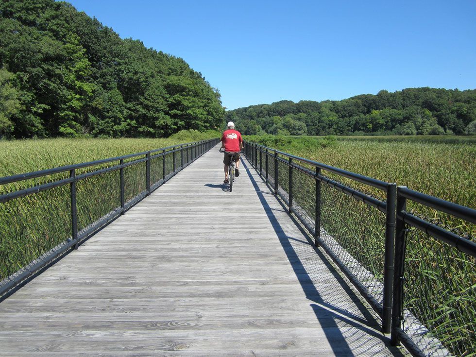
Then at the Charlotte welcome sign
, the path diverges from the sidewalk and heads downhill for a long time, ending up at Turning Point Park, a very beautiful, long, winding boardwalk on the Genesee.
![Deer! [PHOTO: Ryan Green]](https://www.rochestersubway.com/images/photos/rgbike-bike-to-lake-ontario-21b-deer.jpg?ref=senseofplace.dev)
Before we reach the bottom, we pass within ten feet of some deer.
![Turning Point Park. [PHOTO: Ryan Green]](https://www.rochestersubway.com/images/photos/rgbike-bike-to-lake-ontario-22-turning-point-park.jpg?ref=senseofplace.dev)
We head back on the path for a short time... and down to Turning Point Park.
![Turning Point Park boardwalk. [PHOTO: Ryan Green]](https://www.rochestersubway.com/images/photos/rgbike-bike-to-lake-ontario-23-turning-point-park-boardwalk.jpg?ref=senseofplace.dev)
![Turning Point Park boardwalk. [PHOTO: Ryan Green]](https://www.rochestersubway.com/images/photos/rgbike-bike-to-lake-ontario-24-turning-point-park-boardwalk2.jpg?ref=senseofplace.dev)
![Turning Point Park boardwalk. [PHOTO: Ryan Green]](https://www.rochestersubway.com/images/photos/rgbike-bike-to-lake-ontario-24-turning-point-park-boardwalk4.jpg?ref=senseofplace.dev)
![Colonel Patrick O'Rorke Memorial Bridge. [PHOTO: Ryan Green]](https://www.rochestersubway.com/images/photos/rgbike-bike-to-lake-ontario-26-orork-bridge.jpg?ref=senseofplace.dev)
Soon after, we can start to smell the "sea" and enter Rochester's harbor.
![Here's the Harbor Town Belle, one of the many boats available historical or dining cruises in the Rochester Area. [PHOTO: Ryan Green]](https://www.rochestersubway.com/images/photos/rgbike-bike-to-lake-ontario-26b-harbor-town-belle.jpg?ref=senseofplace.dev)
Here's the Harbor Town Belle, one of the many boats available historical or dining cruises in the Rochester Area.
![Hojack Swing Bridge. Now Demolished. [PHOTO: Ryan Green]](https://www.rochestersubway.com/images/photos/rgbike-bike-to-lake-ontario-27-hojack-swing-bridge.jpg?ref=senseofplace.dev)
We See the Hojack Swing Bridge, which has now been demolished.
![Charlotte Lighthouse. [PHOTO: Ryan Green]](https://www.rochestersubway.com/images/photos/rgbike-bike-to-lake-ontario-28-charlotte-lighthouse.jpg?ref=senseofplace.dev)
And the beautiful Charlotte-Genesee Lighthouse is above us.
![Port of Rochester. [PHOTO: Ryan Green]](https://www.rochestersubway.com/images/photos/rgbike-bike-to-lake-ontario-29-port-of-rochester.jpg?ref=senseofplace.dev)
Here is where the ferry to Toronto once docked. The large parking lot was used for cars waiting entrance onto the ship.
![Ferry terminal building. [PHOTO: Ryan Green]](https://www.rochestersubway.com/images/photos/rgbike-bike-to-lake-ontario-30-ferry-terminal.jpg?ref=senseofplace.dev)
The building, itself, now has restaurants and shops.
![Ontario Beach Pavilion. [PHOTO: Ryan Green]](https://www.rochestersubway.com/images/photos/rgbike-bike-to-lake-ontario-31-ontario-beach-pavilion.jpg?ref=senseofplace.dev)
And here are some areas in and around Charlotte Beach AKA Lake Ontario Beach Park...
![Ontario Beach boardwalk. [PHOTO: Ryan Green]](https://www.rochestersubway.com/images/photos/rgbike-bike-to-lake-ontario-32-ontario-beach-boardwalk.jpg?ref=senseofplace.dev)
![Ontario Beach. [PHOTO: Ryan Green]](https://www.rochestersubway.com/images/photos/rgbike-bike-to-lake-ontario-33-ontario-beach.jpg?ref=senseofplace.dev)
![Volleyball at Ontario Beach. [PHOTO: Ryan Green]](https://www.rochestersubway.com/images/photos/rgbike-bike-to-lake-ontario-34-ontario-beach-volleyball.jpg?ref=senseofplace.dev)
![Ontario Beach pier. [PHOTO: Ryan Green]](https://www.rochestersubway.com/images/photos/rgbike-bike-to-lake-ontario-35-ontario-beach-pier.jpg?ref=senseofplace.dev)
Now we head on the pier, and end up a half mile out onto Lake Ontario. The lighthouse here is nothing to marvel at, though.
![Ontario Beach pier. [PHOTO: Ryan Green]](https://www.rochestersubway.com/images/photos/rgbike-bike-to-lake-ontario-36-ontario-beach-pier2.jpg?ref=senseofplace.dev)
![Ontario Beach pier. [PHOTO: Ryan Green]](https://www.rochestersubway.com/images/photos/rgbike-bike-to-lake-ontario-37-ontario-beach-pier3.jpg?ref=senseofplace.dev)
And Looking back.
![This area has a handful of nice restaurants. [PHOTO: Ryan Green]](https://www.rochestersubway.com/images/photos/rgbike-bike-to-lake-ontario-37b-ontario-beach-restaurants.jpg?ref=senseofplace.dev)
Then, we head west a bit. This area has a handful of nice restaurants and feels like a small seaside commercial area you'd perhaps find along the Atlantic Ocean.
![Here's the Roger Robach Community Center, which serves as a bathhouse and banquet facility. [PHOTO: Ryan Green]](https://www.rochestersubway.com/images/photos/rgbike-bike-to-lake-ontario-37c-roger-robach-community-center.jpg?ref=senseofplace.dev)
Here's the Roger Robach Community Center, which serves as a bathhouse. It has bathrooms, showers, and lockers for beachgoers. There is also a large banquet hall which can be rented and has a "Big Band Dance Series" for senior citizens.
![A little detour along Beach Avenue takes us to the 'secret' sidewalk. [PHOTO: Ryan Green]](https://www.rochestersubway.com/images/photos/rgbike-bike-to-lake-ontario-38-secret-sidewalk.jpg?ref=senseofplace.dev)
The path west then takes an interesting turn. This is a very unique area: the path is a public sidewalk , but it passes between lakeside properties and their beach-fronts. I discovered it thanks to an amazing website called Rochester Subway (maybe you've heard of it?!)
![A little detour along Beach Avenue takes us to the 'secret' sidewalk. [PHOTO: Ryan Green]](https://www.rochestersubway.com/images/photos/rgbike-bike-to-lake-ontario-39-secret-sidewalk2.jpg?ref=senseofplace.dev)
![A little detour along Beach Avenue takes us to the 'secret' sidewalk. [PHOTO: Ryan Green]](https://www.rochestersubway.com/images/photos/rgbike-bike-to-lake-ontario-40-secret-sidewalk3.jpg?ref=senseofplace.dev)
![Over the O'rorke Bridge to Irondequoit! [PHOTO: Flickr, Dougtone]](https://www.rochestersubway.com/images/photos/rgbike-bike-to-lake-ontario-41-orork-bridge-Dougtone.jpg?ref=senseofplace.dev)
Then we swing back east and a bit south to cross the closest bridge over the river, the Colonel Patrick O'Rorke Memorial Bridge.
![This part is known as the Irondequoit Lakeside Multi-Use Trail. [PHOTO: Ryan Green]](https://www.rochestersubway.com/images/photos/rgbike-bike-to-lake-ontario-41b-lakeshore-sign.jpg?ref=senseofplace.dev)
This part is known as the Irondequoit Lakeside Multi-Use Trail, and it consists mainly of rideable sidewalks. It has a couple areas to rest with maps and history of the area. We follow the recommended trail, taking a right on St Paul Blvd, then a left onto Lake Shore Blvd.
![Durand Eastman Beach. [PHOTO: Ryan Green]](https://www.rochestersubway.com/images/photos/rgbike-bike-to-lake-ontario-42-durand-eastman-beach-sign.jpg?ref=senseofplace.dev)
We then arrive at the Durand Eastman Beach, just as popular, if not more popular than the former beach. Certainly, it seems more popular for swimming.
![Durand Eastman Beach. [PHOTO: Ryan Green]](https://www.rochestersubway.com/images/photos/rgbike-bike-to-lake-ontario-43-durand-eastman-beach.jpg?ref=senseofplace.dev)
![Durand Eastman Beach. [PHOTO: Ryan Green]](https://www.rochestersubway.com/images/photos/rgbike-bike-to-lake-ontario-44-durand-eastman-beach-driftwood.jpg?ref=senseofplace.dev)
![Durand Eastman Beach. [PHOTO: Ryan Green]](https://www.rochestersubway.com/images/photos/rgbike-bike-to-lake-ontario-45-durand-eastman-beach-grass.jpg?ref=senseofplace.dev)
![Durand Eastman Beach, boardwalk. [PHOTO: Ryan Green]](https://www.rochestersubway.com/images/photos/rgbike-bike-to-lake-ontario-46-durand-eastman-boardwalk.jpg?ref=senseofplace.dev)
We continue east into Irondequoit, over a bridge and up a meandering path before heading back onto sidewalks.
![Durand Eastman Beach, boardwalk. [PHOTO: Ryan Green]](https://www.rochestersubway.com/images/photos/rgbike-bike-to-lake-ontario-46b-durand-eastman-boardwalk.jpg?ref=senseofplace.dev)
![Parkside Diner and Whispering Pines Miniature Golf. [PHOTO: Ryan Green]](https://www.rochestersubway.com/images/photos/rgbike-bike-to-lake-ontario-46c-parkside-diner-mini-golf.jpg?ref=senseofplace.dev)
The path joins the sidewalk at Culver Rd
, and we continue north and east past Parkside Diner and Whispering Pines Mini Golf. The sidewalk on the left side of the road disappears, however, so it is a good idea to cross over and ride on the right, if you haven't been already.
![Seabreeze. [PHOTO: Ryan Green]](https://www.rochestersubway.com/images/photos/rgbike-bike-to-lake-ontario-46d-seabreeze.jpg?ref=senseofplace.dev)
Coming up to the lake and Seabreeze Amusement Park! The Irondequoit waterfront area has many restaurants as well.
![The beach at Seabreeze. [PHOTO: Ryan Green]](https://www.rochestersubway.com/images/photos/rgbike-bike-to-lake-ontario-48-seabreeze-park-beach2.jpg?ref=senseofplace.dev)
![Seabreeze park beach. [PHOTO: Ryan Green]](https://www.rochestersubway.com/images/photos/rgbike-bike-to-lake-ontario-47-seabreeze-park-beach.jpg?ref=senseofplace.dev)
![The beach at Seabreeze. [PHOTO: Ryan Green]](https://www.rochestersubway.com/images/photos/rgbike-bike-to-lake-ontario-49-seabreeze-park-beach3.jpg?ref=senseofplace.dev)
![The pier at Seabreeze. [PHOTO: Ryan Green]](https://www.rochestersubway.com/images/photos/rgbike-bike-to-lake-ontario-50-seabreeze-pier.jpg?ref=senseofplace.dev)
This area is called "Sea Breeze." The pier is similar to the one at the first beach, with an anticlimactic lighthouse, but beautiful scenery. This is at the mouth of Irondequoit Bay. A small bridge to the east side of the mouth remains open to boat traffic from early April until early November. Cars wishing to cross the bay at this time period must do so south.
![The pier at Seabreeze. [PHOTO: Ryan Green]](https://www.rochestersubway.com/images/photos/rgbike-bike-to-lake-ontario-51-seabreeze-pier.jpg?ref=senseofplace.dev)
![The pier at Seabreeze. [PHOTO: Ryan Green]](https://www.rochestersubway.com/images/photos/rgbike-bike-to-lake-ontario-52-seabreeze-pier.jpg?ref=senseofplace.dev)
![Sunset over Lake Ontario. [PHOTO: Ryan Green]](https://www.rochestersubway.com/images/photos/rgbike-bike-to-lake-ontario-53-seabreeze-pier.jpg?ref=senseofplace.dev)
Unfortunately, my camera died at this point. Certainly, taking the Genesee Riverway Trail back is the least stressful, but since we are so far east and the sun is setting, it might be wiser to try a different (shorter) way back. Culver Road
or Kings Highway/Goodman Street
seem like decent streets to bike on. I chose Kings Highway simply because it sounded more interesting to say "I rode on Kings Highway" than "I rode on Culver Road."
We head back west a bit to hook up with Kings Highway, taking care when crossing Lake Shore Boulevard at Durand Eastman Park.
Kings Highway is quite scenic. It feels as though you are riding though a mountainside far away from a city. The good thing is that the elevation rise is mainly in the beginning, here (you get though the pain due to gravity early). The rest of the route is not steeply uphill.
Here's a view of Kings Highway
after you get past Titus Avenue. There aren't many shoulders on the road, but there are always sidewalks. The traffic is not too bad.
As Kings Highway morphs into Goodman Street
, we enter the neighborhood of Group 14621. This area often gets a bad rep, but it is fine passing through on a bike.
Finally, I reach Goodman & Main Street
and the Public Market District just before darkness falls. I take a right onto Main to get back downtown.
For more info on the Genesee Riverway Trail (and others) visit Rochester Trails
* * *
About Ryan Green:
Ryan Green is from Albany, NY. He went to undergrad for Chemical engineering and Electrical engineering at SUNY Buffalo, and while in Buffalo, caught the industrial history/architecture/urban exploration bug. He volunteered at the Buffalo Central Terminal a few times. He is now attending University of Rochester for a Masters in Materials Science and is a member of the UofR Urban Exploration Club.