This article was scraped from Rochester Subway. This is a blog about Rochester history and urbanism has not been published since 2017. The current owners are now publishing link spam which made me want to preserve this history.. The original article was published September 03, 2013 and can be found here.
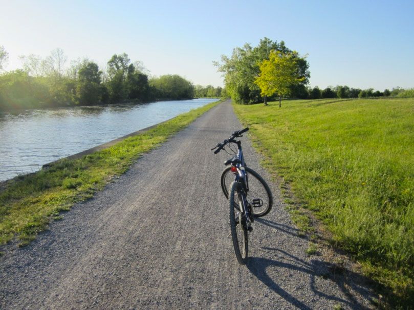
![Ryan Green takes us on a bike ride from downtown Rochester to Fairport. [PHOTO: Ryan Green]](https://www.rochestersubway.com/images/photos/rgbike-erie-canal-path-return-04.jpg?ref=senseofplace.dev)
The following is a guest post submitted by Ryan Green .
Submit your story today .
This is the first in a series of photo tours aimed at encouraging people in the Rochester area--regardless of cycling ability--to get out and enjoy the plethora of trails we have. It is written as an introduction, although most people around here are probably already familiar with some of the trails. Disclaimer: I am not a local... and no where near a veteran cyclist!
Before we begin, I want to point out an advantage Rochester has over some of its upstate neighbors of similar size using Google maps... Buffalo , Rochester , Syracuse/Central NY , Albany/Capital District . Granted, these maps are not 100% accurate. Nor are many of the paths paved. Still it helps give us an idea, in part, why Rochester was named the most bike friendly region in upstate New York (just barely making it on to the top 50 bike friendly cities in the USA
).
![The route from downtown Rochester to Fairport. 17 miles one way. Slightly downhill. No roads to cross. [IMAGE: Google Earth]](https://www.rochestersubway.com/images/photos/rgbike-rochester-fairport-bike-route.jpg?ref=senseofplace.dev)
This photo-tour highlights one of the easiest, most scenic rides in the Rochester Area - downtown Rochester to Fairport
. 17 miles one-way, it is slightly net downhill to Fairport. And once you are en route, you never have to cross any roads! You are alongside either the Genesee River or Erie Canal almost the entire time.
![We begin on the city's entrance to the Genesee Riverway Trail, at the entrance to the Rochester Subway, just south of Dinosaur BBQ. [PHOTO: Ryan Green]](https://www.rochestersubway.com/images/photos/rgbike-genesee-riverway-trail-downtown.jpg?ref=senseofplace.dev)
We begin at the city's entrance to the Genesee Riverway Trail [ View map
]. Near the entrance to the Rochester Subway, just south of Dinosaur BBQ. This area has been greatly improved of the course of the last year. Let's go!
![A quick Look back at the skyline from the Riverway Trail. [PHOTO: Ryan Green]](https://www.rochestersubway.com/images/photos/rgbike-genesee-riverway-trail-skyline.jpg?ref=senseofplace.dev)
A quick Look back at the skyline from the Riverway Trail.
![The path near the Erie Harbor Apartments has seen a recent upgrade. [PHOTO: Ryan Green]](https://www.rochestersubway.com/images/photos/rgbike-genesee-riverway-trail-erie-harbor-01.jpg?ref=senseofplace.dev)
The path near the Erie Harbor Apartments has seen a recent upgrade.
![Genesee Riverway Trail. [PHOTO: Ryan Green]](https://www.rochestersubway.com/images/photos/rgbike-genesee-riverway-trail-erie-harbor-02.jpg?ref=senseofplace.dev)
![The relatively newly converted train bridge (Erie-Lackawanna Railroad Bridge) that links the U of R to the west bank Genesee Riverway Trail. [PHOTO: Ryan Green]](https://www.rochestersubway.com/images/photos/rgbike-erie-lackawanna-rail-bridge.jpg?ref=senseofplace.dev)
The relatively newly converted train bridge (Erie-Lackawanna Railroad Bridge) that links the U of R to the west bank Genesee Riverway Trail.
![Shots from the University of Rochester and Genesee Valley Park... [PHOTO: Ryan Green]](https://www.rochestersubway.com/images/photos/rgbike-genesee-riverway-trail-university-of-rochester-01.jpg?ref=senseofplace.dev)
Shots from the University of Rochester and Genesee Valley Park...
![Shots from the University of Rochester and Genesee Valley Park... [PHOTO: Ryan Green]](https://www.rochestersubway.com/images/photos/rgbike-genesee-riverway-trail-university-of-rochester-02.jpg?ref=senseofplace.dev)
![Shots from the University of Rochester and Genesee Valley Park... [PHOTO: Ryan Green]](https://www.rochestersubway.com/images/photos/rgbike-genesee-riverway-trail-genesee-valley-park-01.jpg?ref=senseofplace.dev)
![Shots from the University of Rochester and Genesee Valley Park... [PHOTO: Ryan Green]](https://www.rochestersubway.com/images/photos/rgbike-genesee-riverway-trail-genesee-valley-park-02.jpg?ref=senseofplace.dev)
![Shots from the University of Rochester and Genesee Valley Park... [PHOTO: Ryan Green]](https://www.rochestersubway.com/images/photos/rgbike-genesee-riverway-trail-genesee-valley-park-03.jpg?ref=senseofplace.dev)
![The Genesee Waterways Center, which provides kayaking and canoe rentals to let you explore the canal and river in another healthy way. [PHOTO: Ryan Green]](https://www.rochestersubway.com/images/photos/rgbike-genesee-riverway-trail-genesee-valley-park-04.jpg?ref=senseofplace.dev)
The last Image shows the Genesee Waterways Center, which provides kayaking and canoe rentals to let you explore the canal and river in another healthy way.
At the park, there are a few bridges, one crosses the river to hook up with the westbound canal trail and southern river trail/Genesee Valley Greenway, and two others cross the canal for access to the park/golf course and parking to the south. To continue on the Eastbound Erie Canal Heritage Trail, you can cut across the park or loop around the outer path. You do not cross any bridges.
![After leaving Genesee Valley Park, we see two old railroad bridges that cross over the canal and I-390. This is the Lehigh Valley Trail, which heads south, passing through Henrietta. [PHOTO: Ryan Green]](https://www.rochestersubway.com/images/photos/rgbike-erie-canal-path-near-390.jpg?ref=senseofplace.dev)
Now we begin the adventure east. Soon after, we see two old railroad bridges that cross over the canal and I-390. This is the Lehigh Valley Trail, which heads south, passing through Henrietta.
![Erie Canal Path. [PHOTO: Ryan Green]](https://www.rochestersubway.com/images/photos/rgbike-erie-canal-path-power-lines.jpg?ref=senseofplace.dev)
![Along the path, you will find various construction projects going on. [PHOTO: Ryan Green]](https://www.rochestersubway.com/images/photos/rgbike-erie-canal-path-construction.jpg?ref=senseofplace.dev)
Along the path, you will find various construction projects going on.
![Near the 590/390 Intersection, there are paths leading to Brighton. [PHOTO: Ryan Green]](https://www.rochestersubway.com/images/photos/rgbike-erie-canal-path-split.jpg?ref=senseofplace.dev)
Near the 590/390 Intersection, there are paths leading to Brighton.
![The city now seems far away. This was taken near the Meridian Centre Park. [PHOTO: Ryan Green]](https://www.rochestersubway.com/images/photos/rgbike-erie-canal-path-skyline.jpg?ref=senseofplace.dev)
The city now seems far away. This was taken near the Meridian Centre Park.
![Various images along the path before reaching Pittsford. On the way, we pass Locks 33 then 32. [PHOTO: Ryan Green]](https://www.rochestersubway.com/images/photos/rgbike-erie-canal-path-01.jpg?ref=senseofplace.dev)
Various images along the path before reaching Pittsford. On the way, we pass Locks 33 then 32. And a very nice area with water on both sides of the path.
![xxx [PHOTO: Ryan Green]](https://www.rochestersubway.com/images/photos/rgbike-erie-canal-path-02.jpg?ref=senseofplace.dev)
![xxx [PHOTO: Ryan Green]](https://www.rochestersubway.com/images/photos/rgbike-erie-canal-path-lock-32.jpg?ref=senseofplace.dev)
![A very nice area with water on both sides of the path. [PHOTO: Ryan Green]](https://www.rochestersubway.com/images/photos/rgbike-erie-canal-path-04.jpg?ref=senseofplace.dev)
![A very nice area with water on both sides of the path. [PHOTO: Ryan Green]](https://www.rochestersubway.com/images/photos/rgbike-erie-canal-path-05.jpg?ref=senseofplace.dev)
![At Lock 32, there is a newly created tunnel for the path. [PHOTO: Ryan Green]](https://www.rochestersubway.com/images/photos/rgbike-erie-canal-path-lock-32-tunnel.jpg?ref=senseofplace.dev)
At lock 33, you have a choice of either carrying your bike down stairs or crossing the relatively quiet Edgewood Avenue. At Lock 32, there is a newly created tunnel for the path.
![One of many boat docks along the way. [PHOTO: Ryan Green]](https://www.rochestersubway.com/images/photos/rgbike-erie-canal-path-boat-dock.jpg?ref=senseofplace.dev)
![If you take the detour near the Pittsford Sewer Dept., you will see this stylish fellow. [PHOTO: Ryan Green]](https://www.rochestersubway.com/images/photos/rgbike-erie-canal-path-detour.jpg?ref=senseofplace.dev)
Near the Pittsford Sewer Department, there may or not be a detour required, but it is well marked and short. If you go along the detour, you will see this stylish fellow.
![After entering Pittsford we see a high school crew regatta meet. [PHOTO: Ryan Green]](https://www.rochestersubway.com/images/photos/rgbike-erie-canal-path-pittsford-regatta.jpg?ref=senseofplace.dev)
After crossing under the Monroe Avenue bridge, and enter Pittsford, we see this... It turns out that day was a high school crew regatta meet. You never know what surprises you will find on the trails!
![If you chose to stay on the trail, the village asks you to walk your bike through the populated areas. [PHOTO: Ryan Green]](https://www.rochestersubway.com/images/photos/rgbike-erie-canal-path-walk-your-bike.jpg?ref=senseofplace.dev)
Before we see various scenes of beautiful Pittsford, take note that if you chose to stay on the trail, the village asks you to walk your bike through the populated areas. If you wish to ride through, you can head off the path and ride on Schoen Place.
![In Pittsford, there are plenty of water fountains (also in Fairport; there are water fountains at the locks but when I tried them, they didn't work). [PHOTO: Ryan Green]](https://www.rochestersubway.com/images/photos/rgbike-erie-canal-path-pittsford-schoen-place-10.jpg?ref=senseofplace.dev)
In Pittsford, there are plenty of water fountains (also in Fairport; there are water fountains at the locks but when I tried them, they didn't work). It's an excellent pit stop to rest, "refuel", and perhaps enjoy some gelato!
![Along the Erie Canal Path in Pittsford. [PHOTO: Ryan Green]](https://www.rochestersubway.com/images/photos/rgbike-erie-canal-path-pittsford-schoen-place-08.jpg?ref=senseofplace.dev)
![Along the Erie Canal Path in Pittsford. [PHOTO: Ryan Green]](https://www.rochestersubway.com/images/photos/rgbike-erie-canal-path-pittsford-schoen-place-01.jpg?ref=senseofplace.dev)
![Along the Erie Canal Path in Pittsford. [PHOTO: Ryan Green]](https://www.rochestersubway.com/images/photos/rgbike-erie-canal-path-pittsford-schoen-place-02.jpg?ref=senseofplace.dev)
![Along the Erie Canal Path in Pittsford. [PHOTO: Ryan Green]](https://www.rochestersubway.com/images/photos/rgbike-erie-canal-path-pittsford-schoen-place-03.jpg?ref=senseofplace.dev)
![Along the Erie Canal Path in Pittsford. [PHOTO: Ryan Green]](https://www.rochestersubway.com/images/photos/rgbike-erie-canal-path-pittsford-schoen-place-04.jpg?ref=senseofplace.dev)
![Along the Erie Canal Path in Pittsford. [PHOTO: Ryan Green]](https://www.rochestersubway.com/images/photos/rgbike-erie-canal-path-pittsford-schoen-place-05.jpg?ref=senseofplace.dev)
![Along the Erie Canal Path in Pittsford. [PHOTO: Ryan Green]](https://www.rochestersubway.com/images/photos/rgbike-erie-canal-path-pittsford-schoen-place-06.jpg?ref=senseofplace.dev)
![Along the Erie Canal Path in Pittsford. [PHOTO: Ryan Green]](https://www.rochestersubway.com/images/photos/rgbike-erie-canal-path-pittsford-schoen-place-07.jpg?ref=senseofplace.dev)
![Along the Erie Canal Path in Pittsford. [PHOTO: Ryan Green]](https://www.rochestersubway.com/images/photos/rgbike-erie-canal-path-pittsford-schoen-place-09.jpg?ref=senseofplace.dev)
![As we leave Pittsford, the trail pavement ends. However, the finely crushed stone should not be a problem for the vast majority of bike tires. [PHOTO: Ryan Green]](https://www.rochestersubway.com/images/photos/rgbike-erie-canal-path-crushed-stone.jpg?ref=senseofplace.dev)
As we leave Pittsford, the trail pavement ends. However, the finely crushed stone should not be a problem for the vast majority of bike tires.
![Oh, look, the Colonial Belle. Let's race it to Fairport - shouldn't be difficult at 10 mph! [PHOTO: Ryan Green]](https://www.rochestersubway.com/images/photos/rgbike-erie-canal-path-colonial-belle-01.jpg?ref=senseofplace.dev)
Oh, look, the Colonial Belle. Let's race it to Fairport - shouldn't be difficult at 10 mph!
![xxx [PHOTO: Ryan Green]](https://www.rochestersubway.com/images/photos/rgbike-erie-canal-path-colonial-belle-02.jpg?ref=senseofplace.dev)
![The Colonial Belle. [PHOTO: Ryan Green]](https://www.rochestersubway.com/images/photos/rgbike-erie-canal-path-colonial-belle-03.jpg?ref=senseofplace.dev)
![Erie Canal Path nearing Bushnell's Basin. [PHOTO: Ryan Green]](https://www.rochestersubway.com/images/photos/rgbike-erie-canal-path-before-bushnells-basin-01.jpg?ref=senseofplace.dev)
![Erie Canal Path nearing Bushnell's Basin. [PHOTO: Ryan Green]](https://www.rochestersubway.com/images/photos/rgbike-erie-canal-path-before-bushnells-basin-02.jpg?ref=senseofplace.dev)
![Bushnell's Basin, a tiny hamlet with an impressive waterfront. [PHOTO: Ryan Green]](https://www.rochestersubway.com/images/photos/rgbike-erie-canal-path-bushnells-basin-01.jpg?ref=senseofplace.dev)
We then reach Bushnell's Basin, a tiny hamlet with an impressive waterfront. Like most towns on the canal, it has excellent signage to guide you around town or help you relate where you are on the trail.
![Bushnell's Basin. [PHOTO: Ryan Green]](https://www.rochestersubway.com/images/photos/rgbike-erie-canal-path-bushnells-basin-02.jpg?ref=senseofplace.dev)
![Bushnell's Basin. [PHOTO: Ryan Green]](https://www.rochestersubway.com/images/photos/rgbike-erie-canal-path-bushnells-basin-03.jpg?ref=senseofplace.dev)
![Erie Canal Path sign. [PHOTO: Ryan Green]](https://www.rochestersubway.com/images/photos/rgbike-erie-canal-path-sign.jpg?ref=senseofplace.dev)
Let's continue!
![A nice little deck. [PHOTO: Ryan Green]](https://www.rochestersubway.com/images/photos/rgbike-erie-canal-path-deck-chairs.jpg?ref=senseofplace.dev)
![Watch for geese and mallards. [PHOTO: Ryan Green]](https://www.rochestersubway.com/images/photos/rgbike-erie-canal-path-ducks.jpg?ref=senseofplace.dev)
It seems like the most treacherous part of our journey is passing this party of geese and mallards.
![Perinton Park has bathroom facilities, tennis & basketball courts, and a playground. [PHOTO: Ryan Green]](https://www.rochestersubway.com/images/photos/rgbike-erie-canal-path-perinton-park-01.jpg?ref=senseofplace.dev)
We now have reached Perinton Park, which has bathroom facilities (also tennis & basketball courts and a playground). When on the Canal Trail, you often meet people from around the region and around the state. The woman on the left in the first picture rode all the way from Lockport!
![Near Perinton Park along the Erie Canal Path. [PHOTO: Ryan Green]](https://www.rochestersubway.com/images/photos/rgbike-erie-canal-path-perinton-park-02.jpg?ref=senseofplace.dev)
![Near Perinton Park along the Erie Canal Path. [PHOTO: Ryan Green]](https://www.rochestersubway.com/images/photos/rgbike-erie-canal-path-perinton-park-03.jpg?ref=senseofplace.dev)
![Near Perinton Park along the Erie Canal Path. [PHOTO: Ryan Green]](https://www.rochestersubway.com/images/photos/rgbike-erie-canal-path-perinton-park-04.jpg?ref=senseofplace.dev)
![Near Perinton Park along the Erie Canal Path. [PHOTO: Ryan Green]](https://www.rochestersubway.com/images/photos/rgbike-erie-canal-path-perinton-park-05.jpg?ref=senseofplace.dev)
![Some nice canal townhouses, and then, when we turn around a bend, we see Fairport's signature lift-bridge. [PHOTO: Ryan Green]](https://www.rochestersubway.com/images/photos/rgbike-erie-canal-path-perinton-park-06.jpg?ref=senseofplace.dev)
Some nice canal townhouses, and then, when we turn around a bend, we see Fairport's signature lift-bridge.
![Fairport! We made it! [PHOTO: Ryan Green]](https://www.rochestersubway.com/images/photos/rgbike-erie-canal-path-fairport-01.jpg?ref=senseofplace.dev)
We have made it!
![On a bike it's easy to appreciate the little things around the town. [PHOTO: Ryan Green]](https://www.rochestersubway.com/images/photos/rgbike-erie-canal-path-fairport-02.jpg?ref=senseofplace.dev)
My first visit to this town was on this trip, and I feel as though you gain more of an appreciation for the little things around the town this way, rather than if you were to drive your car here, park, and go to your destination. Some images around town...
![Fairport, NY. Along the Erie Canal Path. [PHOTO: Ryan Green]](https://www.rochestersubway.com/images/photos/rgbike-erie-canal-path-fairport-03.jpg?ref=senseofplace.dev)
![Fairport, NY. Along the Erie Canal Path. [PHOTO: Ryan Green]](https://www.rochestersubway.com/images/photos/rgbike-erie-canal-path-fairport-04.jpg?ref=senseofplace.dev)
![Fairport, NY. Along the Erie Canal Path. [PHOTO: Ryan Green]](https://www.rochestersubway.com/images/photos/rgbike-erie-canal-path-fairport-05.jpg?ref=senseofplace.dev)
![Fairport, NY. Along the Erie Canal Path. [PHOTO: Ryan Green]](https://www.rochestersubway.com/images/photos/rgbike-erie-canal-path-fairport-06.jpg?ref=senseofplace.dev)
![Fairport, NY. Along the Erie Canal Path. [PHOTO: Ryan Green]](https://www.rochestersubway.com/images/photos/rgbike-erie-canal-path-fairport-07.jpg?ref=senseofplace.dev)
![Fairport, NY. Along the Erie Canal Path. [PHOTO: Ryan Green]](https://www.rochestersubway.com/images/photos/rgbike-erie-canal-path-fairport-08.jpg?ref=senseofplace.dev)
![Fairport, NY. Along the Erie Canal Path. [PHOTO: Ryan Green]](https://www.rochestersubway.com/images/photos/rgbike-erie-canal-path-fairport-09.jpg?ref=senseofplace.dev)
![Fairport, NY. Along the Erie Canal Path. [PHOTO: Ryan Green]](https://www.rochestersubway.com/images/photos/rgbike-erie-canal-path-fairport-10.jpg?ref=senseofplace.dev)
![Fairport, NY. Along the Erie Canal Path. [PHOTO: Ryan Green]](https://www.rochestersubway.com/images/photos/rgbike-erie-canal-path-fairport-11.jpg?ref=senseofplace.dev)
![Fairport, NY. Along the Erie Canal Path. [PHOTO: Ryan Green]](https://www.rochestersubway.com/images/photos/rgbike-erie-canal-path-fairport-12.jpg?ref=senseofplace.dev)
![I decided to eat at the Towpath Cafe, a very nice coffee shop/restaurant with a friendly staff. [PHOTO: Ryan Green]](https://www.rochestersubway.com/images/photos/rgbike-erie-canal-path-fairport-towpath-cafe-01.jpg?ref=senseofplace.dev)
I decided to eat at the Towpath Cafe, a very nice coffee shop/restaurant with a friendly staff.
![My reward for completing half the trip! [PHOTO: Ryan Green]](https://www.rochestersubway.com/images/photos/rgbike-erie-canal-path-fairport-towpath-cafe-02.jpg?ref=senseofplace.dev)
My reward for completing half the trip!
![After I head out of the restaurant, I head just a bit further east, until I completed 19.00 miles one way. [PHOTO: Ryan Green]](https://www.rochestersubway.com/images/photos/rgbike-erie-canal-path-odometer.jpg?ref=senseofplace.dev)
After I head out of the restaurant, I head just a bit further east, until I completed 19.00 miles one way.
![Notice that, at this point, the path is paved again (it has been since Perinton Park). [PHOTO: Ryan Green]](https://www.rochestersubway.com/images/photos/rgbike-erie-canal-path-past-fairport.jpg?ref=senseofplace.dev)
Notice that, at this point, the path is paved again (it has been since Perinton Park).
![The sun is setting though, so we must hurry back, now, on a stomach full of beer and bacon cheeseburger! [PHOTO: Ryan Green]](https://www.rochestersubway.com/images/photos/rgbike-erie-canal-path-return-01.jpg?ref=senseofplace.dev)
The sun is setting though, so we must hurry back, now, on a stomach full of beer and bacon cheeseburger!
![Various images along the journey back. As the sun sets, it creates amazing photo opportunities! [PHOTO: Ryan Green]](https://www.rochestersubway.com/images/photos/rgbike-erie-canal-path-return-02.jpg?ref=senseofplace.dev)
Various images along the journey back. As the sun sets, it creates amazing photo opportunities!
![Various images along the journey back. As the sun sets, it creates amazing photo opportunities! [PHOTO: Ryan Green]](https://www.rochestersubway.com/images/photos/rgbike-erie-canal-path-return-03.jpg?ref=senseofplace.dev)
![Various images along the journey back. As the sun sets, it creates amazing photo opportunities! [PHOTO: Ryan Green]](https://www.rochestersubway.com/images/photos/rgbike-erie-canal-path-return-05.jpg?ref=senseofplace.dev)
![Various images along the journey back. As the sun sets, it creates amazing photo opportunities! [PHOTO: Ryan Green]](https://www.rochestersubway.com/images/photos/rgbike-erie-canal-path-return-06.jpg?ref=senseofplace.dev)
![Various images along the journey back. As the sun sets, it creates amazing photo opportunities! [PHOTO: Ryan Green]](https://www.rochestersubway.com/images/photos/rgbike-erie-canal-path-return-07.jpg?ref=senseofplace.dev)
![As we pass by the northern edge of the U of R, we see a glimpse of Rochester, and know we will make it before darkness. What a beautiful city that is! [PHOTO: Ryan Green]](https://www.rochestersubway.com/images/photos/rgbike-erie-canal-path-return-08.jpg?ref=senseofplace.dev)
As we pass by the northern edge of the U of R, we see a glimpse of our home, and know we will make it before darkness. What a beautiful city that is!
![The final trip total was 37.9 miles and a ride duration of 3 hrs 25 minutes. [PHOTO: Ryan Green]](https://www.rochestersubway.com/images/photos/rgbike-erie-canal-path-return-09.jpg?ref=senseofplace.dev)
The final trip total was 37.9 miles and a ride duration of 3 hrs 25 minutes, due to a deviation from the path shown, and frequent stops to take photos. If starting in the morning, almost everyone, regardless of riding ability, should have no trouble doing this entire trip well before sunset (with a 30 minute stop in Pittsford and hour+ stop in Fairport, included).
Although the ride is very easy, please note that the entire trip is not recommended until you are used to sitting on a bike for that long and have rode similar distances before.
Fairport's Canal Days
are scheduled for May 31 through June 2, and what better way to fully appreciate the past and present of the canal that links most of us New Yorkers together than by cycling along the canal to and/or from the event? (Sorry, this article didn't get posted until well after Canal Days... but you can still catch Fairport's Autumn Scarecrow Festival
!)
So get out there and enjoy the ride!
Stay tuned for future cycling photo-tours including westbound to Brockport, northbound to Lake Ontario, and the southern Greenway/Lehigh Valley loop trail.
* * *
About Ryan Green:
Ryan Green is from Albany, NY. He went to undergrad for Chemical engineering and Electrical engineering at SUNY Buffalo, and while in Buffalo, caught the industrial history/architecture/urban exploration bug. He volunteered at the Buffalo Central Terminal a few times. He is now attending University of Rochester for a Masters in Materials Science and is a member of the UofR Urban Exploration Club.
